Search Results
286 Results found
![](https://historicalmaps.yale-nus.edu.sg/rails/active_storage/representations/eyJfcmFpbHMiOnsibWVzc2FnZSI6IkJBaHBBcjhEIiwiZXhwIjpudWxsLCJwdXIiOiJibG9iX2lkIn19--4880b204be4327ed71ac0fd16c99653037bac51c/eyJfcmFpbHMiOnsibWVzc2FnZSI6IkJBaDdCam9MY21WemFYcGxTU0lNTkRBd2VETXdNQVk2QmtWVSIsImV4cCI6bnVsbCwicHVyIjoidmFyaWF0aW9uIn19--bc467f5637e8b6d3bfb826116f92b6bfedfbf03a/bodleian-0131.jpeg)
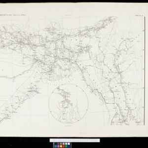
Map to illustrate Convention of March 1st 1894 between Great Britain and China: From the Map of Upper Burma
1894
Myanmar
Map of the border region between the Shan States of northeast Burma (Myanmar) and China's Yunnan Province, illustrating the result of the 1894 Sino-British boundary convention. The Burma side is more detailed, with mountains, rivers and settlements.
![](https://historicalmaps.yale-nus.edu.sg/rails/active_storage/representations/eyJfcmFpbHMiOnsibWVzc2FnZSI6IkJBaHBIZz09IiwiZXhwIjpudWxsLCJwdXIiOiJibG9iX2lkIn19--33100ca356c197cb84b75b0e6840635d22fbd495/eyJfcmFpbHMiOnsibWVzc2FnZSI6IkJBaDdCam9MY21WemFYcGxTU0lNTkRBd2VETXdNQVk2QmtWVSIsImV4cCI6bnVsbCwicHVyIjoidmFyaWF0aW9uIn19--bc467f5637e8b6d3bfb826116f92b6bfedfbf03a/bodleian-0276.jpeg)
A map of British North Borneo
1894
Malaysia, Brunei, Indonesia
The colonial territories of British North Borneo are shown in pink on this late 19th century map, with Brunei and Sarawak in green, and Dutch colonial territory in yellow. Sea routes around the British Empire are depicted on an inset map.
![](https://historicalmaps.yale-nus.edu.sg/rails/active_storage/representations/eyJfcmFpbHMiOnsibWVzc2FnZSI6IkJBaHBBclVEIiwiZXhwIjpudWxsLCJwdXIiOiJibG9iX2lkIn19--5292b1e595402c191a606721b63b97751842f9b5/eyJfcmFpbHMiOnsibWVzc2FnZSI6IkJBaDdCam9MY21WemFYcGxTU0lNTkRBd2VETXdNQVk2QmtWVSIsImV4cCI6bnVsbCwicHVyIjoidmFyaWF0aW9uIn19--bc467f5637e8b6d3bfb826116f92b6bfedfbf03a/bodleian-0349.jpeg)
Map of the Johore Territory 1893
1894
Malaysia, Singapore
Map of the Malay state of Johor, and Singapore. The route of a proposed railway north from Johor Bahru is shown. Apart from rivers and mountains, much of the terrain is blank, with labels such as ‘Unexplored Hill Country’ or ‘Dense Jungle and Swamp’.
![](https://historicalmaps.yale-nus.edu.sg/rails/active_storage/representations/eyJfcmFpbHMiOnsibWVzc2FnZSI6IkJBaHBBbTBGIiwiZXhwIjpudWxsLCJwdXIiOiJibG9iX2lkIn19--8092a97ae08729c9205bfb8a594f5657778b63a7/eyJfcmFpbHMiOnsibWVzc2FnZSI6IkJBaDdCam9MY21WemFYcGxTU0lNTkRBd2VETXdNQVk2QmtWVSIsImV4cCI6bnVsbCwicHVyIjoidmFyaWF0aW9uIn19--bc467f5637e8b6d3bfb826116f92b6bfedfbf03a/bodleian-0382.jpeg)
Trade Routes in the Far East
1894
Brunei, Cambodia, Indonesia, Laos, Malaysia, Myanmar, Philippines, Singapore, Thailand, Vietnam
Map of stream ship trade routes around Southeast Asia. Rivers, railways, submarine telegraph cables, lighthouses (fixed, revolving and flashing), graving docks and coaling stations are marked. An inset map shows a railway route from Britain to Asia.
![](https://historicalmaps.yale-nus.edu.sg/rails/active_storage/representations/eyJfcmFpbHMiOnsibWVzc2FnZSI6IkJBaHBBbjBFIiwiZXhwIjpudWxsLCJwdXIiOiJibG9iX2lkIn19--5af5a77e805a551de5a7005a31e66fde67b9d020/eyJfcmFpbHMiOnsibWVzc2FnZSI6IkJBaDdCam9MY21WemFYcGxTU0lNTkRBd2VETXdNQVk2QmtWVSIsImV4cCI6bnVsbCwicHVyIjoidmFyaWF0aW9uIn19--bc467f5637e8b6d3bfb826116f92b6bfedfbf03a/bodleian-0392.jpeg)
Queensland & British New Guinea
c.1894-1897
Indonesia, Papua New Guinea
The first two sheets of this eight-sheet map focus on British New Guinea, with German and Dutch colonial areas of New Guinea also shown in part. There is a line marking a proposed change in border between Dutch and British territory.
- Myanmar172
- Thailand140
- Malaysia136
- Indonesia135
- Singapore109
- Vietnam109
- Cambodia100
- Laos96
- Philippines89
- Brunei83
- East Timor71
- Southeast Asia71
- more Simple Location »
- Siam116
- Malay Peninsula99
- Sumatra97
- Java88
- Borneo82
- Sulawesi63
- Burma60
- Celebes60
- New Guinea50
- South China Sea49
- Upper Burma46
- Western New Guinea42
- more Detailed Location »
- Kampong/Village60
- Military Fort34
- Residential Area28
- Hospital27
- Church24
- Cemetery/Columbarium20
- Police Station17
- Military Barracks15
- Jail/Prison14
- Public Space14
- Missionary Building12
- Temple12
- Court of Law10
- Mosque10
- more Settlement Features »
- [remove]Scale286
- Longitude and Latitude249
- Contour Lines/Elevation120
- Written Note/Details77
- Compass Rose59
- Rhumbline Network22
- Thuillier, Colonel H.R.18
- Moll, Herman10
- Strahan, Major General Charles9
- Johnston, Keith (A.K.)7
- Johnston, William7
- Arrowsmith, John6
- Walker, John6
- Wyld, James6
- more Map Maker »
- Survey of India Offices, Calcutta56
- Intelligence Division, War Office22
- Edward Stanford17
- Stanford's Geographical Establishment15
- Surveyor General's Office, Brisbane13
- Royal Geographical Society9
- Intelligence Branch, War Office8
- Laurie & Whittle7
- more Printer/Publisher »
- London117
- Edinburgh24
- Dehradun23
- Brisbane12
- New York6
- Singapore4
- Calcutta3
- Chicago2
- more Place of Publication »