
Search Results


Stanford's Library Map of Asia
1899
Brunei, Cambodia, East Timor, Indonesia, Laos, Malaysia, Myanmar, Philippines, Singapore, Southeast Asia, Thailand, Vietnam
Southeast Asia is on sheet four of this map. British colonial territory—British Burma, the Straits Settlements, Sarawak, Brunei, British North Borneo—is highlighted in red, with Dutch, Spanish, French and Portuguese territory also shown.

Zuidelijk gedeelte van de Chineesche zee: Blad I
1899
Malaysia, Singapore, Indonesia
Navigation map of the southern part of the South China Sea, including the straits of Malacca and Singapore, and the Riau Archipelago. Bathymetry (sea depth), lighthouses, shoals and other obstructions are marked, with hills to use as landmarks.
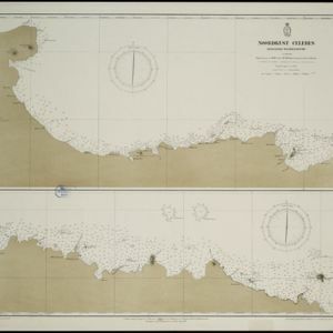
Noordkust Celebes: Hoek Kandi tot hoek Dondo
1899
Indonesia
Two navigation maps for the north coast of Celebes (Sulawesi), featuring bathymetry (sea depth), landmark mountains, reefs and shoals. Obstructions in the water are marked ‘kr’ (coral), ‘m’ (mud), ‘s’ (shells), ‘st’ (stones), and ‘z’ (sand).


Riouw archipel: Straat Doerian en oostelijke vaarwaters
1899
Indonesia
Navigation map of the waters and straits around some of the islands of the Riau Archipelago, between Sumatra and Batam. Bathymetry (sea depth), current and tide data, reefs, shoals and other obstructions (clay, mud, shells, stones, sand) are marked.

Vaarwaters en ankerplaatsen op de oostkust van Borneo: Blad III
1899
Indonesia
Navigation maps of two bays on the southeast coast of Borneo. Anchorages, bathymetry (sea depth), buoys, shoals and other obstructions are shown. There is an inset map of the roadstead—a body of water sheltered from tides/currents—at Balikpapan Bay.


Overzichtskaart van de Residentie Besoeki
1899
Indonesia
This map of the residency of Besoeki (Banyuwangi Regency, East Java) is divided into regencies and districts. Heights of mountains and settlements are given in metres, and distances are shown along roads. Sugar factories and fishing ponds are marked.


Kaart der residentie Zuider- en Ooster-afdeeling van Borneo
1899
Indonesia
On this map, the residency of South and East Borneo is divided into departments (green borders) and provinces (yellow borders). There is an inset plan of the city of Banjarmasin, with rivers, buildings, residential areas, roads and crops marked.
- Filter from 1535 to 1900
- Indonesia729
- Malaysia434
- Myanmar419
- Thailand402
- Singapore367
- Vietnam361
- Cambodia353
- Brunei334
- Laos328
- Philippines323
- East Timor290
- Southeast Asia274
- more Simple Location »
- Port100
- Railway Station40
- Pier26
- River694
- Road246
- Path151
- Railway/Tramway130
- Postal Route86
- Telegraph/Telephone45
- Canal32
- Bridge24
- Legend398
- Inset Map239
- Cartouche225
- Illustration166
- Elevation98
- Coat of Arms87
- [remove]Longitude and Latitude900
- [remove]Scale900
- Contour Lines/Elevation395
- Compass Rose261
- Written Note/Details231
- Rhumbline Network80


