
Search Results


Atlas van Nederlandsch Oost-Indië
c.1897-1904
Indonesia
Very detailed atlas of the entire Dutch East Indies, over 16 map sheets, with a cover and overview map. Includes topographic maps, inset maps of cities and islands, and maps featuring land and sea routes, languages, geology, colonial territory etc.

Kaart van de Golf van Tomini of Gorontalo en omliggende landen
1878
Indonesia
Map of the Minahasa and East peninsulas of Celebes (Sulawesi) focusing on the road system (shown by red lines). There are four inset maps, including one showing indigenous tribal areas, and a list of places with their latitude, longitude and height.


Nederlandsch Oost-Indië
1865
Brunei, Cambodia, East Timor, Indonesia, Laos, Malaysia, Myanmar, Vietnam, Thailand, Southeast Asia, Singapore, Philippines, Papua New Guinea
This detailed map of the Dutch East Indies in the mid-19th century contains a great deal of information: topographical details, settlements and administrative areas, roads, railways and maritime routes, telegraph lines, inset maps etc.
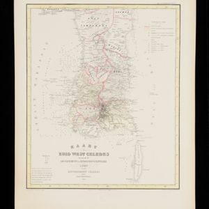
Kaart van Zuid West Celebes, bevattende de Gouvernements en Bondgenootschappelijke Landen van het Gouvernement Celebes
1860
Indonesia
Map of the South Peninsula of Celebes (Sulawesi). The Spermonde Archipelago in the Makassar Strait is very detailed with islands, shoals, reefs and bathymetry. (From ‘Algemeene Atlas van Nederlandsche Indie [General Atlas of the Dutch East Indies]’.)


Algemeene Kaart van het Gouvernement der Moluksche Eilanden
1855
Indonesia
Map of the Dutch colonial administrative regions (residencies) of the Moluccas (Maluku Islands), with Celebes (Sulawesi) and New Guinea. (From ‘Algemeene Atlas van Nederlandsche Indie [General Atlas of the Dutch East Indies]’.)

Kaart van Noord & Oost-Celebes, bevattende gedeelton der residentien Manado en Ternate
1854
Indonesia
Map of northern and eastern Celebes (Sulawesi) colour-coded by administrative region: the residencies of Manado (red borders) and Ternate (yellow borders). (From ‘Algemeene Atlas van Nederlandsche Indie [General Atlas of the Dutch East Indies]’.)

Algemeene Atlas van Nederlandsche Indie
c.1853-1862
Indonesia
Atlas featuring over 60 detailed maps of the Dutch East Indies: 24 maps cover Java; the remainder cover the rest of the Dutch East Indies. There are three index maps. (All the maps in this atlas are also presented separately on this platform.)

Kaart van de Minahassa in de Residentie Manado
1853
Indonesia
Map of part of the Dutch colonial administrative region of Manado, on the Minahasa Peninsula, Celebes (Sulawesi). Includes an elevation view of the mountains. (From ‘Algemeene Atlas van Nederlandsche Indie [General Atlas of the Dutch East Indies]’.)

Carte générale des possessions néerlandaises aux Indes orientales
1846
Brunei, East Timor, Indonesia, Malaysia, Philippines, Singapore
Map of the Asian colonial possessions of the Netherlands (Dutch East Indies), with an inset of the heights of some of the region’s mountains. A note describes the average temperature, barometer reading and magnetic declination in Batavia at the time.
- [remove]District/Administrative Border24
- Colonial Possessions15
- Civic/Metropolitan Border5
- National Border2
- Regional Border1


