Search

Search Results

Map of the Kingdom of Siam and its dependencies

eventc.1900

location_onMyanmar, Malaysia, Singapore, Thailand, Laos, Cambodia, Vietnam

The border of the Kingdom of Siam (Thailand) and its internal administrative districts are highlighted in yellow. Inset maps show the cities of Bangkok, Chiengmai (Chiang Mai) and Luang Pra Bang (Luang Prabang) in more detail.

Plan of the town and suburbs of Rangoon

eventc.1895-1897

location_onMyanmar

Detailed plan of the city of Rangoon (Yangon, Myanmar) with commercial, religious, government and military buildings, surrounded by lakes, fields of crops and villages. Someone has drawn details on the map of areas that have undergone ‘levelling’.

Plan of Singapore town

event1893

location_onSingapore

Large-scale plan of Singapore city, spread over eight sheets. Includes the central civic/business area around the Singapore River, Tanjong Pagar dock, and residential areas. The city is surrounded by suburbs, cemeteries, mangroves, vegetable gardens.

[Omgeving van het Toba meer, afdeelingen Bataklanden, onderafdeelingen Samosir, Toba en Hoogvlakte van Toba]

event1890

location_onIndonesia

Hand-drawn map of the southern part of Lake Toba in Sumatra, with roads, rivers and paths marked. Mountains, forest and rice fields are also shown, as are missionary buildings for indigenous and European people.

Kaart der Bataklanden en van het eiland Nijas

event1890

location_onIndonesia

A large-scale map of northern Sumatra, spread over 16 sheets, and divided into administrative regions. The island of Nijas (Nias) is marked with the locations of local tribes, and there is a list of other maps referenced in producing the map.

Plan of Port Moresby and the road to the Lolokie River: New Giunea

event1887

location_onPapua New Guinea

This map focuses on the capital city of British New Guinea, Port Moresby, and the road heading north-east from the city to the Laloki River. Along the road, there are descriptions of the terrain (‘Open flat fairly grasses timbered with bastard Gum’).

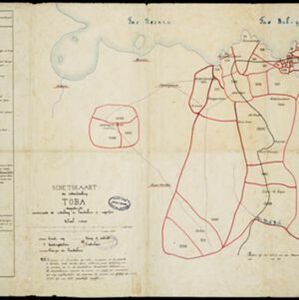
Schetskaart der onderafdeeling Toba: aantoonende de verdeeling in hoendoelans of negorijen

event1886

location_onIndonesia

Hand-drawn map of the district of Toba at the southern shore of Lake Toba, Sumatra, further divided into administrative areas (details of which are listed). Roads and paths are marked, and there are two missionary buildings indicated with crosses.

Sketch of Hué

event1885

location_onVietnam

Map of the city of Hué (Huế) on the Perfume River, east coast of Vietnam. There are forts, villages and rice fields along the river. In the city, there is the royal palace within walls and a moat, French military barracks and other colonial areas.

Map of the Malacca territory

event1878

location_onMalaysia

A late 19th century map of the town of Malacca and its surrounding area, including jungles, forests, mountains, rivers, roads, villages, tapioca estates and factories, and police stations. There is even a leper hospital on an island off the coast.

Military cantonments: town and suburbs of Akyab, 1853-54

event1866

location_onMyanmar

Plan of British military installations in the port town of Akyab, Burma (Sittwe, Myanmar), featuring piers on the Kolladyne River (Kaladan River), hospitals, a work house, mission house, hotel, bazaar, burial grounds, religious buildings etc.

Islas Filipinas. Segunda hoja central

event1852

location_onPhilippines

Produced in Spain, this mid-19th century map details the islands of Visayas, Mindanao and Palawan in the Philippines archipelago. Bathymetry (sea depth) is marked around the islands and on four detailed inset maps of ports in the region.

close