Search

Search Results

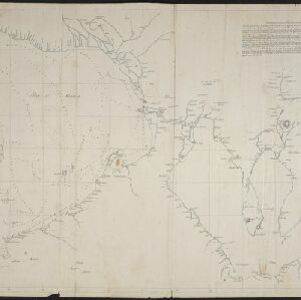
[Manuscript map of Manila Harbor and Bay Lake]

event1810

location_onPhilippines

This early 19th century hand-drawn map of Manila Bay has detailed instructions in Spanish on how to enter the bay, and the port at Cavite. Bathymetry (water depth), the mouths of rivers, and landmark mountains are shown to aid navigation.

Mapa de las Yslas Philipinas

event1744

location_onIndonesia, Philippines

First published in 1734, and commonly known as the ‘Velarde map’, this map by the Spanish cartographer Pedro Murillo Velarde is regarded as the first important map of the Philippines. This is a later version, lacking 12 drawings on the map's sides.

close

  • Filter from 1744 to 1810

Current results range from 1744 to 1810