
Search Results
Filter
Land Features
Mountain/Volcano
Remove constraint Land Features: Mountain/Volcano
Land Routes
Bridge
Remove constraint Land Routes: Bridge
Settlement Features
Church
Remove constraint Settlement Features: Church
Political Regions
Civic/Metropolitan Border
Remove constraint Political Regions: Civic/Metropolitan Border
Transport Hubs
Pier
Remove constraint Transport Hubs: Pier
3 Results found


Atlas van Nederlandsch Oost-Indië
c.1897-1904
Indonesia
Very detailed atlas of the entire Dutch East Indies, over 16 map sheets, with a cover and overview map. Includes topographic maps, inset maps of cities and islands, and maps featuring land and sea routes, languages, geology, colonial territory etc.
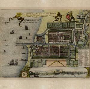
Ware affbeeldinge wegens het casteel ende stadt Batavia gelegen opt groot eylant Java anno 1669
1670
Indonesia
A plan of the important port of Batavia (Jakarta), with the fort, river, city streets and fields. Decorative illustrations include ships in the harbour, a view of the city and mountains, and the city’s coat of arms: a lion holding a sword and shield.
- Filter from 1670 to 1900
- [remove]Civic/Metropolitan Border3
- District/Administrative Border2
- Colonial Possessions1
- [remove]Mountain/Volcano3
- Wetlands2
- Jungle/Wooded Area1
- Wild Animals1


