Search

Search Results

Wegennet der gemeente Medan

event1895

location_onIndonesia

This map of the town of Medan, north Sumatra, is colour-coded to show land use, reflecting the details of a land lease contract, and including a military camp, Sultan’s palace and land, and residential, agricultural, municipal and government areas.

Hoofdplaats-Medan

event1895

location_onIndonesia

Map of the city of Medan on the north coast of Sumatra, featuring the Deli and Babura rivers and two railway lines. Other notable locations include a race track, military camp, Sultan’s palace (Maimun Palace), police station, offices, hospitals etc.

Koninginne baai met Emma haven

event1894

location_onIndonesia

Map of Koninginne Baai (Bayur Bay, west coast of Sumatra) used to navigate Emma Haven (now Port of Teluk Bayur). It features bathymetry (sea depth), reefs and shoals, as well as lighthouses, buoys and two elevations (side views) of coastal mountains.

Kaart van Groot Atjeh

event1894

location_onIndonesia

This map of Groot Atjeh (Aceh, northern Sumatra) focuses on Dutch military posts in and around the city of Kota Radja (Banda Aceh) during the Aceh War. It shows new permanent and temporary posts being added over the period 1884 to 1893.

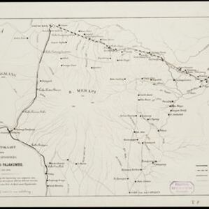
Overzichtskaart van den ontworpen spoorweg Fort de Kock-Pajakombo

event1894

location_onIndonesia

A map of railway lines between Fort de Kock (Bukittinggi) and Pajakombo (Payakumbuh) in western Sumatra. The map includes existing line, planned line and rack railway line (a line with a rack and pinion system so it can operate on steep slopes).

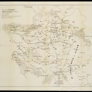
Kaart van de Karo landen (Oost Sumatra)

event1891

location_onIndonesia

A map recording five Dutch expeditions through the Karo Lands of northern Sumatra. The mountainous terrain is represented by contour lines, with peaks’ heights marked. The names of groups of the indigenous Karo people are shown in large letters.

Deli: Spoorweg maatschappij

event1891

location_onIndonesia

A map of the railway/tramway system of the Deli district on the northeast Sumatra coast. Existing and projected lines are shown, with stops and stations, as well as ‘draagbaar’ railways (a railway with movable tracks made by the Decauville company).

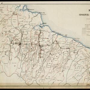
Kaart van het gebied bezet in Groot-Atjeh

event1891

location_onIndonesia

A map of Groot-Atjceh and the city of Kota Radja (modern Banda Aceh) at the northern tip of Sumatra, detailing routes (rivers, roads, railways), crops (rice, banana, sugarcane, betel, reed, alang-alang, bamboo) and land features (forests, wetlands).

Schetskaart van een gedeelte van Midden Sumatra

event1891

location_onIndonesia

A map of central Sumatra spread over four sheets, divided into administrative districts, and with roads, railways and settlements marked. An inset map acts as a locator map, showing the main map’s location within Sumatra.

Schetskaart van het boven stroom gebied der Asahan rivier, aek Asahan en aek Bila

event1890

location_onIndonesia

Hand-drawn map of the upper basin of the Asahan River, just southeast of Lake Toba in northern Sumatra. Rivers such as the Hoewaloe and Bila are marked in blue, with roads in red, mountains shaded brown, and settlements named.

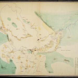
[Omgeving van het Toba meer, afdeelingen Bataklanden, onderafdeelingen Samosir, Toba en Hoogvlakte van Toba]

event1890

location_onIndonesia

Hand-drawn map of the southern part of Lake Toba in Sumatra, with roads, rivers and paths marked. Mountains, forest and rice fields are also shown, as are missionary buildings for indigenous and European people.

Kaart der Bataklanden en van het eiland Nijas

event1890

location_onIndonesia

A large-scale map of northern Sumatra, spread over 16 sheets, and divided into administrative regions. The island of Nijas (Nias) is marked with the locations of local tribes, and there is a list of other maps referenced in producing the map.

close