Facsimile of map given to the French Ambassador 29th Aug. 1889 as indicating the Approximate Boundaries of Siam to the North West & North such as they have hitherto been considered event1893 location_onCambodia, Laos, Myanmar, Thailand, Vietnam
Map of the Kingdom of Siam and its dependencies event1888 location_onCambodia, Laos, Malaysia, Myanmar, Thailand, Vietnam
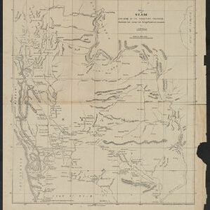
Map of Siam and some of its tributary provinces event1870 location_onCambodia, Laos, Myanmar, Thailand
The Island of Ceylon / Burmah, Siam and Anam event1870 location_onMyanmar, Laos, Cambodia, Thailand, Vietnam, Malaysia
Chart of the China Sea event1864 location_onPapua New Guinea, Indonesia, Malaysia, Cambodia, East Timor, Philippines, Singapore, Thailand, Vietnam
A sketch of the rivers of Siam from the observations of the American missionaries eventc.1860-1869 location_onThailand
Eastern Islands: Birmah &c. event1846 location_onBrunei, Cambodia, East Timor, Indonesia, Laos, Malaysia, Myanmar, Philippines, Singapore, Southeast Asia, Thailand, Vietnam
East India Islands eventc.1844-1846 location_onBrunei, Cambodia, East Timor, Indonesia, Laos, Malaysia, Myanmar, Philippines, Singapore, Southeast Asia, Thailand, Vietnam
Map of the Burman Empire including also Siam, Cochin-China, Ton-king and Malaya event1842 location_onVietnam, Malaysia, Myanmar, Cambodia, Thailand, Laos, Indonesia, Singapore, Brunei
Map of the Burman Empire including also Siam, Cochin-China, Ton-king and Malaya event1842 location_onVietnam, Myanmar, Malaysia, Indonesia, Thailand, Laos, Cambodia, Brunei, Singapore