Search Results
13 Results found
![](https://historicalmaps.yale-nus.edu.sg/rails/active_storage/representations/eyJfcmFpbHMiOnsibWVzc2FnZSI6IkJBaHBBY3M9IiwiZXhwIjpudWxsLCJwdXIiOiJibG9iX2lkIn19--230833c7ee81289c92f6093244601b1a513b82e9/eyJfcmFpbHMiOnsibWVzc2FnZSI6IkJBaDdCam9MY21WemFYcGxTU0lNTkRBd2VETXdNQVk2QmtWVSIsImV4cCI6bnVsbCwicHVyIjoidmFyaWF0aW9uIn19--bc467f5637e8b6d3bfb826116f92b6bfedfbf03a/leiden-2017185.jpeg)
Atlas van Nederlandsch Oost-Indië
c.1897-1904
Indonesia
Very detailed atlas of the entire Dutch East Indies, over 16 map sheets, with a cover and overview map. Includes topographic maps, inset maps of cities and islands, and maps featuring land and sea routes, languages, geology, colonial territory etc.
![](https://historicalmaps.yale-nus.edu.sg/rails/active_storage/representations/eyJfcmFpbHMiOnsibWVzc2FnZSI6IkJBaHBBdVVFIiwiZXhwIjpudWxsLCJwdXIiOiJibG9iX2lkIn19--2fd73599a6ab44fa762c547625f9fab67f996a94/eyJfcmFpbHMiOnsibWVzc2FnZSI6IkJBaDdCam9MY21WemFYcGxTU0lNTkRBd2VETXdNQVk2QmtWVSIsImV4cCI6bnVsbCwicHVyIjoidmFyaWF0aW9uIn19--bc467f5637e8b6d3bfb826116f92b6bfedfbf03a/leiden-1996680.jpeg)
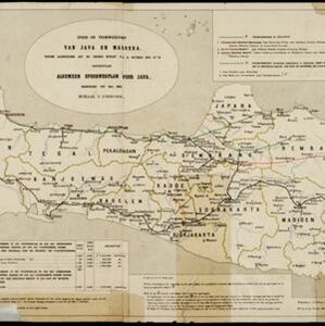
Spoor- en tramwegkaart van Java en Madoera
1894
Indonesia
The railways and tramways of Java and Madoera (Madura) are shown on this late 19th century map, including lines in use, under construction, and being planned. Each line is named, with their route, length, track gauge and construction costs listed.
![](https://historicalmaps.yale-nus.edu.sg/rails/active_storage/representations/eyJfcmFpbHMiOnsibWVzc2FnZSI6IkJBaHBBcE1DIiwiZXhwIjpudWxsLCJwdXIiOiJibG9iX2lkIn19--90d36cc751cc1f334e6a7802d206330f74057082/eyJfcmFpbHMiOnsibWVzc2FnZSI6IkJBaDdCam9MY21WemFYcGxTU0lNTkRBd2VETXdNQVk2QmtWVSIsImV4cCI6bnVsbCwicHVyIjoidmFyaWF0aW9uIn19--bc467f5637e8b6d3bfb826116f92b6bfedfbf03a/leiden-2010844.jpeg)
Kaart van de dichtheid van bevolking van Java en Madoera
1892
Indonesia
This map shows the population density of Java and Madura in 1892. The area is divided into regencies, which are then subdivided into districts, with the districts shaded to represent its population. Each district is also listed under its regency.
![](https://historicalmaps.yale-nus.edu.sg/rails/active_storage/representations/eyJfcmFpbHMiOnsibWVzc2FnZSI6IkJBaHBBc3dDIiwiZXhwIjpudWxsLCJwdXIiOiJibG9iX2lkIn19--e28f5e511f92a3c221c1e25f5d48ee1552f5a2b3/eyJfcmFpbHMiOnsibWVzc2FnZSI6IkJBaDdCam9MY21WemFYcGxTU0lNTkRBd2VETXdNQVk2QmtWVSIsImV4cCI6bnVsbCwicHVyIjoidmFyaWF0aW9uIn19--bc467f5637e8b6d3bfb826116f92b6bfedfbf03a/leiden-2011966.jpeg)
Kaart van den op Java en Madoera reeds in gebruik genomen grond
1892
Indonesia
Land usage statistics are shown on this map of Java and Madura. The amount of land used in each district is indicated by green hash marks, and by a number giving its land use percentage. District names are listed and identified by a letter.
![](https://historicalmaps.yale-nus.edu.sg/rails/active_storage/representations/eyJfcmFpbHMiOnsibWVzc2FnZSI6IkJBaHBBbVVDIiwiZXhwIjpudWxsLCJwdXIiOiJibG9iX2lkIn19--af1675cad807c6a9077bfa01700cb0e92614e63c/eyJfcmFpbHMiOnsibWVzc2FnZSI6IkJBaDdCam9MY21WemFYcGxTU0lNTkRBd2VETXdNQVk2QmtWVSIsImV4cCI6bnVsbCwicHVyIjoidmFyaWF0aW9uIn19--bc467f5637e8b6d3bfb826116f92b6bfedfbf03a/leiden-2011943.jpeg)
Kaart aangevende 1°. de verdeeling van Java en Madura in gewesten en wat de gouvernements-residentiën betreft, ook in afdeelingen en districten
1884
Indonesia
This late 19th century map shows Java and Madura divided into regencies and departments, and further divided into districts. Government land used for growing coffee, businesses, agriculture, railways, postal routes and major roads are also shown.
![](https://historicalmaps.yale-nus.edu.sg/rails/active_storage/representations/eyJfcmFpbHMiOnsibWVzc2FnZSI6IkJBaHBWZz09IiwiZXhwIjpudWxsLCJwdXIiOiJibG9iX2lkIn19--462963ec6babb57d6bac50eab6c1c45473414d5b/eyJfcmFpbHMiOnsibWVzc2FnZSI6IkJBaDdCam9MY21WemFYcGxTU0lNTkRBd2VETXdNQVk2QmtWVSIsImV4cCI6bnVsbCwicHVyIjoidmFyaWF0aW9uIn19--bc467f5637e8b6d3bfb826116f92b6bfedfbf03a/leiden-127184.jpeg)
Algemeene kaart van Nederlandsch Oostindie
c.1839-1855
East Timor, Indonesia, Malaysia, Singapore
This map of the Dutch East Indies is spread over eight sheets, with a hand-drawn cover sheet showing the whole area. There are numerous inset maps of islands, bays, cities etc. Two of the inset maps have a replacement map pasted over them.
![](https://historicalmaps.yale-nus.edu.sg/rails/active_storage/representations/eyJfcmFpbHMiOnsibWVzc2FnZSI6IkJBaHBIdz09IiwiZXhwIjpudWxsLCJwdXIiOiJibG9iX2lkIn19--9ff2db896dbbfa93e7a7df39ef6e35cfd7179a6f/eyJfcmFpbHMiOnsibWVzc2FnZSI6IkJBaDdCam9MY21WemFYcGxTU0lNTkRBd2VETXdNQVk2QmtWVSIsImV4cCI6bnVsbCwicHVyIjoidmFyaWF0aW9uIn19--bc467f5637e8b6d3bfb826116f92b6bfedfbf03a/leiden-000178.jpeg)
A map of Java: chiefly from surveys made during the British administration
1817
Indonesia
Made for ‘A History of Java’ by Sir Stamford Raffles, this map includes a list of administrative districts with their populations, and four inset maps of harbours. Another inset map shows rocks and minerals, mountains and volcanoes, and teak forests.
- Java13
- [remove]Madura13
- Dutch East Indies11
- Batavia5
- Jakarta5
- Madoera5
- Ambon3
- Banda Islands3
- Borneo3
- Celebes3
- Chineesche Zee3
- Java Sea3
- more Detailed Location »
- Kampong/Village5
- Residential Area5
- Cemetery/Columbarium3
- Church3
- Hospital3
- Military Fort3
- Public Space3
- Temple3
- Communal Land/Property2
- Court of Law1
- Jail/Prison1
- Military Barracks1
- Mosque1
- Police Station1
- more Settlement Features »
- [remove]District/Administrative Border13
- Civic/Metropolitan Border3
- Colonial Possessions3
- Scale13
- [remove]Written Note/Details13
- Longitude and Latitude12
- Contour Lines/Elevation8
- Compass Rose2
- Bogaerts, A.J.2
- Derfelden van Hinderstein, Gijsbert Franco von2
- Horsfield, Dr. Thomas2
- LeClercq, I.H.W.2
- Raffles, Sir Thomas Stamford2
- Walker, John2
- Eckstein, Charles1
- Siethoff, J.J. ten1
- more Map Maker »
- Topographische Inrichting3
- A.J. Bogaerts2
- Black, Parbury & Allen2
- Jos. Smulders & Co.2
- Topographische Bureau2
- W.P. van Stockum2
- Departement van Koloniën1
- Intelligence Division, War Office1
- more Printer/Publisher »