Search Results
Kaart van Deli: Afdeeling der residentie Oostkusst van Sumatra
1884
Indonesia
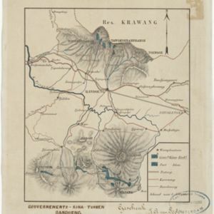
Map of Deli on the east coast of Sumatra, dominated by the numerous rivers that flow from the mountains in the southwest to the Strait of Malacca. The railway lines around the city of Medan are shown in red, and flags indicate a military garrison.
Topographische kaart der residentie Soerabaja
1884
Indonesia
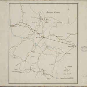
The residency of Soerabaja, East Java, featuring crops (coffee, coconut, sugarcane, rice, alang-alang, bamboo) and fishing ponds. Three inset maps: a triangulation map; a map of distances between settlements by types of transport; Bawean Island.
- Dutch East Indies42
- Java25
- Sumatra18
- Soerabaja8
- Surabaya8
- Aceh6
- Banda Aceh6
- Batavia5
- Jakarta5
- Medan5
- Oostkust van Sumatra5
- Asahan4
- more Detailed Location »
- Kampong/Village30
- Residential Area24
- Cemetery/Columbarium15
- Military Barracks13
- Post Office13
- Church11
- Hospital11
- Military Fort11
- Temple10
- Police Station9
- Public Space9
- Jail/Prison8
- Mosque8
- Palace7
- more Settlement Features »
- Stemfoort, J.W.2
- Bakhuis, Louis August1
- Cronenberg, G.P.F.1
- Donnadieu1
- Eckstein, Charles1
- Geest, Evert de1
- Jongh, W. de1
- McCarthy, James Fitzroy1
- more Map Maker »
- Topographische Bureau19
- Topographische Inrichting7
- Seyffardt's Boekhandel3
- Survey of India Offices, Calcutta3
- J.H. de Bussy2
- De Groot, Kolff en Co.1
- Deli Spoorweg Maatschappij1
- Departement van Koloniën1
- more Printer/Publisher »
- Batavia21
- The Hague8
- Amsterdam5
- Surabaya3
- Dehradun2
- Bandung1
- Edinburgh1
- London1
- more Place of Publication »