Search

Search Results

Principal Dutch colonies in the Indian seas

event1872

location_onBrunei, Indonesia, Malaysia

Two maps of the Dutch East Indies, decorated with drawings of local people and animals. Dutch colonial territory and local sultanates and provinces are highlighted. The heights of Java’s mountains and settlements are displayed in an elevation view.

A map of the East-Indies and the adjacent countries: with the settlements, factories and territories, explaining what belongs to England, Spain, France, Holland, Denmark, Portugal &c.

event1717

location_onBrunei, Cambodia, East Timor, Indonesia, Laos, Malaysia, Myanmar, Philippines, Singapore, Southeast Asia, Thailand, Vietnam

This map showcases the colonial territories of Southeast Asia in the 18th century, with text detailing trading information and the products of each region. There are five inset maps featuring plans of specific trading ports.

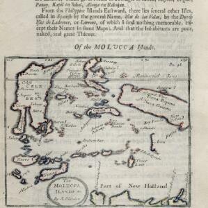
The Molucca Ilands &c.

eventc.1680-1700

location_onEast Timor, Indonesia, Philippines

From Robert Morden’s ‘Geography Rectified’, a description with maps of the known world in the late 17th century. The map shows the Moluccas, but the text describes the Philippines: Spanish colonial rule, trade, the city of Manila and port of Cavite.

close

  • Filter from 1680 to 1872

Current results range from 1680 to 1872