Search Results
Filter
Cultivation/Extraction
Crops
Remove constraint Cultivation/Extraction: Crops
Land Routes
Canal
Remove constraint Land Routes: Canal
Language
English
Remove constraint Language: English
Detailed Location
Java
Remove constraint Detailed Location: Java
Collections
National Library Board Singapore
Remove constraint Collections: National Library Board Singapore
2 Results found

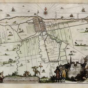
A mapp of Batavia with all itts forts
1704
Indonesia
This early 18th century map of Batavia (Jakarta) shows an important port city, with military forts, a long pier, and many ships at sea. However, the map also shows a city surrounded by fields and plantations, for producing crops and grazing animals.


