Search Results
![](https://historicalmaps.yale-nus.edu.sg/rails/active_storage/representations/eyJfcmFpbHMiOnsibWVzc2FnZSI6IkJBaHBBa3NFIiwiZXhwIjpudWxsLCJwdXIiOiJibG9iX2lkIn19--28d39238d0f41bc8357e4a41fd7f2e663fec2bef/eyJfcmFpbHMiOnsibWVzc2FnZSI6IkJBaDdCam9MY21WemFYcGxTU0lNTkRBd2VETXdNQVk2QmtWVSIsImV4cCI6bnVsbCwicHVyIjoidmFyaWF0aW9uIn19--bc467f5637e8b6d3bfb826116f92b6bfedfbf03a/nlb-050000122.jpeg)
Plan de la ville et forteresse de Malaca: pour servir à l'histoire generale des voyages
1750
Malaysia
This mid-18th century plan of the city of Malaca (Malacca/Melaka) focuses on the military fort (‘A Famosa [The Famous]’), but also includes two churches, a mosque and a Chinese temple. Two markets are also marked, as is the entrance to the port.
![](https://historicalmaps.yale-nus.edu.sg/rails/active_storage/representations/eyJfcmFpbHMiOnsibWVzc2FnZSI6IkJBaHBBalVGIiwiZXhwIjpudWxsLCJwdXIiOiJibG9iX2lkIn19--96d7047491659147f9230decfe6ce6b4d35867f3/eyJfcmFpbHMiOnsibWVzc2FnZSI6IkJBaDdCam9MY21WemFYcGxTU0lNTkRBd2VETXdNQVk2QmtWVSIsImV4cCI6bnVsbCwicHVyIjoidmFyaWF0aW9uIn19--bc467f5637e8b6d3bfb826116f92b6bfedfbf03a/nlb-B26056114C.jpeg)
The principal islands of the East-Indies: explaining what belongs to England, Spain and Holland &c.
1732
Brunei, Cambodia, East Timor, Indonesia, Philippines, Malaysia, Thailand, Vietnam, Singapore, Southeast Asia
The letters ‘E’ or ‘D’ are marked after place names to indicate if they are English or Dutch colonial possessions: e.g. ‘Marleborough Fort E’ on Sumatra or ‘Concordia Fort D’ on Timor. The Philippines are labelled ‘to Spain’.
![](https://historicalmaps.yale-nus.edu.sg/rails/active_storage/representations/eyJfcmFpbHMiOnsibWVzc2FnZSI6IkJBaHBBdUVCIiwiZXhwIjpudWxsLCJwdXIiOiJibG9iX2lkIn19--f9ea5a251d2826c47cb27ba21f5d5f11435b8fda/eyJfcmFpbHMiOnsibWVzc2FnZSI6IkJBaDdCam9MY21WemFYcGxTU0lNTkRBd2VETXdNQVk2QmtWVSIsImV4cCI6bnVsbCwicHVyIjoidmFyaWF0aW9uIn19--bc467f5637e8b6d3bfb826116f92b6bfedfbf03a/nlb-B26056160D.jpeg)
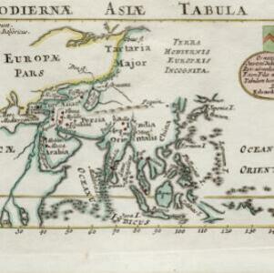
Hodiernæ Asiæ tabula
1700
Brunei, Cambodia, Indonesia, Laos, Malaysia, Myanmar, Papua New Guinea, Philippines, East Timor, Singapore, Southeast Asia, Thailand, Vietnam
The Latin title of this map translates as ‘Map of Today's Asia’, and reflects the knowledge of the region in the very early 18th century. Although lacking detail in Southeast Asia, the map does show the major islands and some cities.
![](https://historicalmaps.yale-nus.edu.sg/rails/active_storage/representations/eyJfcmFpbHMiOnsibWVzc2FnZSI6IkJBaHBBblFCIiwiZXhwIjpudWxsLCJwdXIiOiJibG9iX2lkIn19--6e01cdc330fdcf69a18520668a925d5758e0ed7f/eyJfcmFpbHMiOnsibWVzc2FnZSI6IkJBaDdCam9MY21WemFYcGxTU0lNTkRBd2VETXdNQVk2QmtWVSIsImV4cCI6bnVsbCwicHVyIjoidmFyaWF0aW9uIn19--bc467f5637e8b6d3bfb826116f92b6bfedfbf03a/nlb-B26056036F.jpeg)
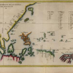
Descripcion de las Indias del Poniente
1623
Brunei, Cambodia, Indonesia, Philippines, Malaysia, Singapore, Thailand, Vietnam
The many inaccuracies and omissions on this early map of Southeast Asia show the limitations of geographical knowledge at the time. There are some interesting details though, such as a legend listing the small islands in the Moluccas and Philippines.
- Malaysia5
- Brunei3
- Cambodia3
- Indonesia3
- Philippines3
- Singapore3
- Thailand3
- Vietnam3
- East Timor2
- Southeast Asia2
- Laos1
- Myanmar1
- more Simple Location »
- [remove]Malacca5
- Borneo3
- Java3
- Melaka3
- Sulawesi3
- Sumatra3
- Celebes2
- Malaca2
- New Guinea2
- Siam2
- Batavia1
- Bay of Siam1
- more Detailed Location »
- [remove]Legend5
- Cartouche1
- Coat of Arms1