
Search Results
4 Results found


A new chart of the eastern straits to China drawn from the best authorities
1800
Indonesia
Two maps of routes around the Flores and Banda seas—through the straits between the Lesser Sunda Islands and the Maluku Islands—towards China. Includes a rhumbline network—a web of lines to help plot routes—bathymetry (sea depth), shoals and reefs.
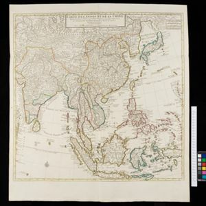
Carte des Indes et de la Chine
c.1722-1774
Brunei, Cambodia, East Timor, Indonesia, Laos, Malaysia, Myanmar, Philippines, Singapore, Southeast Asia, Thailand, Vietnam
This map uses coloured borders to show the ancient kingdoms of Southeast Asia. A label on the island of Borneo states ‘Beajous Idolatres habitans le milieu de l'Isle [Beajous idolaters inhabit the middle of the Island]’.

A new map of the East Indies: taken from M. de Fer's map of Asia, shewing their cheif divisions, cities, towns, ports, rivers, mountains &c.
1701
Brunei, Cambodia, East Timor, Indonesia, Laos, Malaysia, Myanmar, Vietnam, Thailand, Southeast Asia, Singapore, Philippines
This early 18th century map shows Southeast Asia alongside India and part of China, with the names of cities, towns, ports, rivers and mountains marked. A handwritten note at the top left comments on the map's accuracy.


