
Search Results


Kaart van den vierkanten paal (I en II) gouvernements grondgebied te Sintang
1888
Indonesia
The Kapoewas (Kapuas) and Melawi rivers converge on this map of the town of Sintang, Borneo. The town lines the river banks, and is surrounded by fields, forest and marshland. Arrows on the rivers mark the direction of their flow.

Kaart van den vierkanten paal gouvernements-grondgebied te Montrado
1887
Indonesia
A map of government land around the town of Montrado, Borneo, a gold mining centre in the 19th century, as shown by the number of gold mines (‘goudmijn’) marked. There are also crops—coconut, alang-alang, bamboo—and agricultural and fish ponds.


Kaart van den Indischen Archipel aangevende den bestaanden toestand met betrekking tot de Gouvernements Monopoliën van Opium en Zout
1882
Indonesia
Different levels of government monopolies are indicated on this map of the Dutch East Indies by the use of areas of colour (opium trade) and hash marks (salt trade). The inset map of Java is divided into residencies.

Topographische en geologische kaart van Zuid-Sumatra bevattende de residentien Bengkoelen, Palembang en Lampongsche Districten
1880
Indonesia
A topographical and geological map of southern Sumatra, over four sheets. Areas of igneous and sedimentary rock, coal, fossils, petroleum, active volcanoes and hot springs are marked, along with mountains, rivers and marshland, roads and settlements.


Geognostische kaart van het Oembilien kolenveld in de Padangsche bovenlanden, Sumatra's Westkust
1874
Indonesia
A geological map, spread over eight sheets, showing the types of rock and minerals found in the Oembilien coalfield, in the Padang Highlands on Sumatra’s west coast. There are also additional geological profiles.


Geognostisch-mijnbouwkundige kaart van het eiland Bangka, distrikt Blinjoe
1872
Indonesia
A geological map showing the types of rock and minerals found in Blinjoe district on the island of Bangka, off the east coast of Sumatra. Deposits of iron, quartz and tin are marked, and coral is shown at the coast.
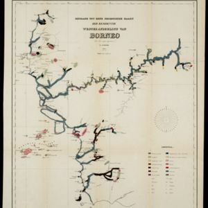
Bijdrage tot eene geologische kaart der residentie Westerafdeeling van Borneo
1858
Indonesia
A geological map of western Borneo made by a mine engineer, showing the types of soil, coal, clay, and rock (limestone, sandstone, granite, basalt), as well as gold, diamonds, tin, copper and iron found along the rivers.

- Filter from 1535 to 1900
- [remove]Indonesia72
- Malaysia39
- Singapore33
- Vietnam30
- Thailand29
- Cambodia27
- Southeast Asia27
- Brunei26
- Myanmar26
- Laos25
- Philippines25
- East Timor22
- more Simple Location »


