
Search Results
29 Results found


A map of the East Indies, from the best authorities
1780
Brunei, Cambodia, East Timor, Indonesia, Laos, Malaysia, Myanmar, Philippines, Singapore, Southeast Asia, Thailand, Vietnam
On this map of Asia, Borneo is labelled ‘The Inland Part of this Island is inhabited by the Biayos a savage People’, a description seen on many contemporary maps. The ancient kingdoms of mainland Southeast Asia are also shown.
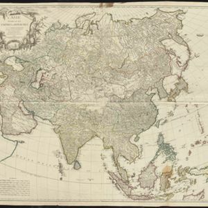
L'Asie divisée en ses Empires et Royaumes
1778
Brunei, Cambodia, East Timor, Indonesia, Laos, Malaysia, Myanmar, Philippines, Singapore, Southeast Asia, Thailand, Vietnam
This map shows the empires and kingdoms of Southeast Asia. Its decorative cartouche features drawings of plants, a camel, a vase, and the heads of children blowing to represent wind. An inset shows tall buildings, possibly Asian temples.

Nieuwe en naukeurige kaart van Asia
1773
Indonesia, Brunei, Cambodia, East Timor, Laos, Malaysia, Myanmar, Papua New Guinea, Philippines, Singapore, Southeast Asia, Thailand, Vietnam
Map of Asia featuring an early—and very vague—depiction of New Britain (‘Nieuw Brittanje’) which was named by the British explorer William Dampier when he visited in 1700. The ‘Straat van Dampier’ is also shown, dividing New Britain from New Guinea.

L'Asie Dressée Selon les Observations de Mrs. De l' Academie Royale des Sciences
1749
Brunei, Cambodia, East Timor, Indonesia, Laos, Malaysia, Myanmar, Singapore, Philippines, Southeast Asia, Thailand, Vietnam
Map of Asia based on observations of members of the French Academy of Sciences. Its decorative cartouche features a drawing of a censer (incense burner).

Carte des Indes Orientales: I. feuille
1748
Myanmar, Cambodia, Indonesia, Laos, Malaysia, Singapore, Thailand, Vietnam
Map featuring the ancient kingdoms of mainland Southeast Asia. The cartouche is embellished with maritime and military paraphernalia. The map is dedicated to William IV, Prince of Orange (Guillaume Charles Henry Friso). Sheet one of two.
- Indonesia29
- [remove]Malaysia29
- Singapore29
- Brunei27
- Cambodia25
- Thailand25
- Laos21
- Myanmar21
- Vietnam21
- East Timor19
- Philippines19
- Southeast Asia19
- more Simple Location »
- [remove]Malacca29
- Sumatra29
- [remove]Sunda Islands29
- Borneo27
- Java27
- Malay Peninsula27
- Sulawesi19
- Isles de la Sonde16
- Maluku Islands15
- Siam13
- Western New Guinea13
- South China Sea12
- more Detailed Location »
- [remove]River29


