
Search Results
52 Results found


Atlas van Nederlandsch Oost-Indië
c.1897-1904
Indonesia
Very detailed atlas of the entire Dutch East Indies, over 16 map sheets, with a cover and overview map. Includes topographic maps, inset maps of cities and islands, and maps featuring land and sea routes, languages, geology, colonial territory etc.


Oost-Indie
c.1867
Brunei, Cambodia, East Timor, Indonesia, Laos, Malaysia, Myanmar, Philippines, Singapore, Southeast Asia, Thailand, Vietnam
Map of the East Indies in the mid-19th century, with Dutch colonial territory (Dutch East Indies) coloured in brown. Dutch administrative regions—such as residencies (‘residentie’) and governorates (‘gouvernement’)—are labelled.
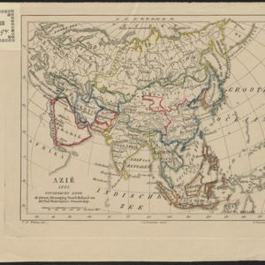
Azië : 1861
1861
Brunei, Cambodia, East Timor, Indonesia, Laos, Malaysia, Myanmar, Papua New Guinea, Philippines, Singapore, Southeast Asia, Thailand, Vietnam
Map of Asia published by the North Holland Regional Association of the Dutch Teachers' Association. Mainland Southeast Asia is labelled ‘Achter Indie [Beyond India]’; the Indonesian Archipelago is labelled ‘Indische Archipel [Indian Archipelago]’.

Algemeene Atlas van Nederlandsche Indie
c.1853-1862
Indonesia
Atlas featuring over 60 detailed maps of the Dutch East Indies: 24 maps cover Java; the remainder cover the rest of the Dutch East Indies. There are three index maps. (All the maps in this atlas are also presented separately on this platform.)

- Filter from 1707 to 1900
- [remove]Borneo52
- [remove]Celebes52
- [remove]Maluku Islands52
- Sulawesi52
- [remove]Sumatra52
- Java51
- Malay Peninsula47
- Western New Guinea39
- Siam33
- South China Sea26
- Malakka21
- Sunda Islands21
- more Detailed Location »


