Search

Search Results

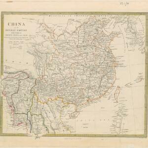
Extension of the Electric Telegraph to Canton, Hong Kong, etc. from the Port of Rangoon

event1860

location_on
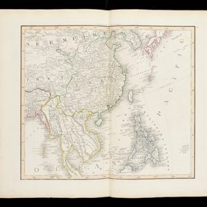
Myanmar, Cambodia, Indonesia, Laos, Malaysia, Singapore, Thailand, Vietnam

Map of a proposed extension of a telegraph system from Rangoon (Yangon, Myanmar) to China. Includes current and projected railways, steam ship routes, and population figures for western China. From the British magazine ‘The Illustrated London News’.

New map of Burma and the regions adjacent

event1857

location_onMyanmar, Thailand

Map of Burma spread over two sheets, labelled with the names of indigenous ‘tribes’ (uppercase red text), mountains, rivers, forests and plantations (teak, bamboo, sappanwood).

China and the Birman Empire: with parts of Cochin-China and Siam

event1853

location_onMyanmar, Thailand, Vietnam, Laos

The northern regions of mid-19th century Southeast Asia are included on this map of China, with the Birman Empire (Myanmar) bordered in green, Siam (Thailand) in blue, and Cochin-China (Vietnam) in yellow. Some of the larger rivers are named.

Malay Archipelago, or East India Islands

event1851

location_onBrunei, Cambodia, East Timor, Indonesia, Laos, Malaysia, Myanmar, Papua New Guinea, Philippines, Singapore, Southeast Asia, Thailand, Vietnam

This mid-19th century map of Southeast Asia is illustrated with drawings of indigenous people from New Guinea, a ‘bee bear’ (probably a sun bear), a sailboat in front of Victoria Mount in New Guinea, and a village and palm trees in Sarawak, Borneo.

Asia

event1850

location_onBrunei, Cambodia, East Timor, Indonesia, Laos, Malaysia, Myanmar, Papua New Guinea, Philippines, Singapore, Southeast Asia, Vietnam, Thailand

This map is decorated with colourful illustrations of people and animals. Of particular interest to Southeast Asia are the paintings of 'Sun-birds of India and the Philippine Isles'.

Mountain chains in Asia & Europe

event1849

location_onCambodia, Indonesia, Laos, Malaysia, Myanmar, Philippines, Singapore, Thailand, Vietnam

Mountain chains are represented by black lines; volcanoes by black dots. Three insets maps: expansion of Reguain—island of Taung-ywa, off the coast of Myanmar—due to volcanic activity; geology of Java (with heights of mountains); volcanoes of Luzon.

S.E. Peninsula and Malaysia

event1849

location_onBrunei, Cambodia, East Timor, Indonesia, Laos, Malaysia, Myanmar, Papua New Guinea, Philippines, Singapore, Southeast Asia, Thailand, Vietnam

The colonial possessions of Britain, the Netherlands, Spain, Portugal and Denmark are shown on this mid-19th century map of Southeast Asia. There are inset maps of Penang Island and Singapore, and text describing the region’s colonial history.

A chart of the Indian and Pacific Oceans with particular plans of the harbours

event1847

location_onBrunei, Cambodia, East Timor, Indonesia, Laos, Malaysia, Myanmar, Papua New Guinea, Philippines, Southeast Asia, Singapore, Thailand, Vietnam

Southeast Asia is shown on sheets two and three of this 12-sheet map of the Indian and Pacific oceans, including detailed inset maps of the straits of Singapore, Bangka, Gaspar and Sunda, with bathymetry (sea depth), shoals, reefs, anchorages etc.

Eastern Islands: Birmah &c.

event1846

location_onBrunei, Cambodia, East Timor, Indonesia, Laos, Malaysia, Myanmar, Philippines, Singapore, Southeast Asia, Thailand, Vietnam

On this map of Southeast Asia, British colonial territory is highlighted within red borders: the Straits Settlements (Singapore, Malacca and Penang) on the west coast of the Malay Peninsula; and British Burma (Chittagong and Aracan, and Tenasserim).

Asia. Plates 42-45 in Lizars' Edinburgh Geographical General Atlas

eventc.1844-1846

location_onBrunei, Cambodia, Indonesia, Laos, Malaysia, Myanmar, Philippines, Thailand, Vietnam

Southeast Asia is featured on the last of the four sheets of this map of Asia. The South China Sea is particularly detailed, with islands, rocks, shoals and reefs named, sometimes dated, and even marked with the name of the ship that mapped them.

East India Islands

eventc.1844-1846

location_onBrunei, Cambodia, East Timor, Indonesia, Laos, Malaysia, Myanmar, Philippines, Singapore, Southeast Asia, Thailand, Vietnam

From ‘Lizars' Edinburgh Geographical General Atlas’, this mid-19th century map was based on an earlier map by the English cartographer John Cary. It highlights the mountain ranges and rivers of Southeast Asia, and also features many place names.

Map of the Burman Empire including also Siam, Cochin-China, Ton-king and Malaya

event1842

location_onVietnam, Malaysia, Myanmar, Cambodia, Thailand, Laos, Indonesia, Singapore, Brunei

Although this mid-19th century map covers all of mainland Southeast Asia, the Burman Empire (Myanmar) is shown in greater detail, especially its districts, rivers and place names. It was produced by the James Wyld, geographer to Queen Victoria.

close