
Search Results
8 Results found


Kaart van den archipel van Riouw, Singapore en Lingga / Kaart van de eilanden Bangka en Blitong
1857
Indonesia, Singapore
Two maps featuring many of the islands between the Malay Peninsula, Sumatra and Borneo. In the top map, Batam, Bintan, Lingga and many of the smaller Riau Islands. In the bottom map, Bangka and Belitung on the east coast of Sumatra.


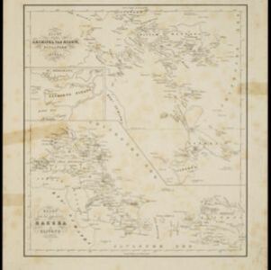
Algemeene kaart van Nederlandsch Oostindie
c.1839-1855
East Timor, Indonesia, Malaysia, Singapore
This map of the Dutch East Indies is spread over eight sheets, with a hand-drawn cover sheet showing the whole area. There are numerous inset maps of islands, bays, cities etc. Two of the inset maps have a replacement map pasted over them.

Partie de la nouvelle grande carte des Indes Orientales, contenant les isles Maldives, Ceylan, Malacca, Sumatra... les isles de Borneo, Iava, Celebes, Mindanao
c.1750
Brunei, East Timor, Indonesia, Malaysia, Papua New Guinea, Philippines, Singapore
Map of maritime Southeast Asia, with four inset maps of locations in the region: Surabaya, some of the Lesser Sumba Islands, and Buton and Muna islands of the coast of Sulawesi. Mountains, forests, settlements and fields are represented pictorially.

Partie de la nouvelle Grande Cartes des Indes Orientales, contenant les Isles Maldives, Ceylan, Malacca, Sumatra &c.
1700
Indonesia, Malaysia, Singapore, Thailand
Sumatra and the Malay Peninsula feature on this map of the Indian Ocean. Enganno Island, west of southern Sumatra, has a label that translates as ‘inhabited by very pernicious savages’. An inset map depicts the Madura Strait between Java and Madura.

Isole dell'Indie divise in Filippine, Molucche e della Sonda
1680
Brunei, Cambodia, East Timor, Indonesia, Malaysia, Laos, Myanmar, Philippines, Singapore, Southeast Asia, Thailand, Vietnam
Dotted lines and colours divide maritime Southeast Asia into three regions on this map: the Philippine archipelago, Maluku Islands and Sunda Islands. The cartouche features cherub mermaids, and a map of mainland Southeast Asia is on the reverse.
- [remove]District/Administrative Border8
- Civic/Metropolitan Border4
- Colonial Possessions4
- National Border2
- Regional Border1
- [remove]Inset Map8
- Legend4
- Illustration3
- Coat of Arms2
- Elevation2
- Cartouche1
- [remove]Longitude and Latitude8
- Scale7
- Compass Rose4
- Contour Lines/Elevation3
- Written Note/Details3


