
Search Results
48 Results found


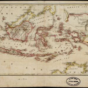
Nederland en deszelfs koloniën
1844
Brunei, East Timor, Indonesia, Malaysia, Singapore
Map of the East Indies, with the borders of Dutch colonial territory marked in brown. The Malay Peninsula (‘Malakka’) has green borders, indicating it is a British possession. Four inset maps show other Dutch territories outside Southeast Asia.

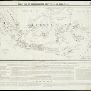
Kaart van de Nederlandsche bezittingen in Oost-Indië
1840
Brunei, East Timor, Indonesia, Malaysia, Philippines, Singapore
This map shows the Dutch colonial possessions in the East Indies in the mid-19th century. The text provides great detail about the people, religion, crops, animals, geography and administration of the Dutch East Indies.
Nederlandsch Oost-Indië
1840
Brunei, East Timor, Indonesia, Malaysia, Papua New Guinea, Philippines, Singapore
The Dutch East Indies are bordered in red on this mid-19th century map. A maritime postal route from China to Europe, via Singapore and Penang, is shown. Another maritime route, from Batavia to Singapore, is also marked.

Asiatic archipelago
1840
Vietnam, Myanmar, Papua New Guinea, Philippines, Singapore, Southeast Asia, Thailand, Malaysia, Laos, Indonesia, East Timor, Brunei, Cambodia
This late 19th century map of Southeast Asia shows the best maritime routes around the region, according to the time of year. There is also an inset map highlighting the rivers and southern islands of Singapore.

Algemeene kaart van Nederlandsch Oostindie
c.1839-1855
East Timor, Indonesia, Malaysia, Singapore
This map of the Dutch East Indies is spread over eight sheets, with a hand-drawn cover sheet showing the whole area. There are numerous inset maps of islands, bays, cities etc. Two of the inset maps have a replacement map pasted over them.

Karte von der Insel Sumatra
1837
Singapore, Indonesia, Malaysia
Based on surveys by Sir Stamford Raffles, this German map of Sumatra focuses on the navigation of coasts and straits, with bathymetry (sea depth), anchor points, shoals and reefs marked, including on inset maps of Singapore and the Bangka Strait.

Karte von der Insel Sumatra
1837
Malaysia, Indonesia, Singapore
Based on surveys by Sir Stamford Raffles, this German map of Sumatra focuses on the navigation of coasts and straits, with bathymetry (sea depth), anchor points, shoals and reefs marked, including on inset maps of Singapore and the Bangka Strait.

Reduzirte Karte vom Chinesischen Meere: 1stes oder Südliches Blatt
1835
Brunei, Cambodia, Indonesia, Malaysia, Singapore, Thailand
Navigation map of the southern South China Sea, with bathymetry (sea depth), islands, shoals and reefs marked. There are four maritime routes to China marked, with notes on what months or monsoon season to use them. Inset map of Gulf of Thailand.
- Malaysia48
- [remove]Singapore48
- Indonesia42
- East Timor33
- Brunei32
- Thailand29
- Philippines25
- Myanmar21
- Cambodia20
- Laos18
- Vietnam18
- Southeast Asia17
- more Simple Location »
- [remove]Inset Map48
- Legend23
- Illustration6
- Coat of Arms5
- Elevation5
- Cartouche3
- [remove]Longitude and Latitude48
- Scale33
- Contour Lines/Elevation28
- Written Note/Details17
- Compass Rose8


