Search Results
21 Results found
![](https://historicalmaps.yale-nus.edu.sg/rails/active_storage/representations/eyJfcmFpbHMiOnsibWVzc2FnZSI6IkJBaHBBcnNDIiwiZXhwIjpudWxsLCJwdXIiOiJibG9iX2lkIn19--18a41205a79515b6d8d3639064d22f2fb72f575c/eyJfcmFpbHMiOnsibWVzc2FnZSI6IkJBaDdCam9MY21WemFYcGxTU0lNTkRBd2VETXdNQVk2QmtWVSIsImV4cCI6bnVsbCwicHVyIjoidmFyaWF0aW9uIn19--bc467f5637e8b6d3bfb826116f92b6bfedfbf03a/leiden-2012250.jpeg)
Kaart de residentie Wester-afdeeling van Borneo
1898
Indonesia
Topographical map of western Borneo, with inset maps of the islands off the west coast, and of the city of Pontianak including the docks and crops grown near the city (rice, coconut, mangosteen, sago, alang-alang, indigo plant, sugarcane, bamboo).
![](https://historicalmaps.yale-nus.edu.sg/rails/active_storage/representations/eyJfcmFpbHMiOnsibWVzc2FnZSI6IkJBaHBBcm9DIiwiZXhwIjpudWxsLCJwdXIiOiJibG9iX2lkIn19--587a19c6724f183bde832fbe787622dbe698687a/eyJfcmFpbHMiOnsibWVzc2FnZSI6IkJBaDdCam9MY21WemFYcGxTU0lNTkRBd2VETXdNQVk2QmtWVSIsImV4cCI6bnVsbCwicHVyIjoidmFyaWF0aW9uIn19--bc467f5637e8b6d3bfb826116f92b6bfedfbf03a/leiden-2013160.jpeg)
Kaart van de residentie Wester-afdeeling van Borneo
1898
Indonesia
Topographical map of western Borneo. Larger settlements are marked with their height above sea-level and with a flag to indicate a military garrison. They also have a letter signifying the local ruler, from Sultan to Lauthai (village elder).
![](https://historicalmaps.yale-nus.edu.sg/rails/active_storage/representations/eyJfcmFpbHMiOnsibWVzc2FnZSI6IkJBaHBBY3M9IiwiZXhwIjpudWxsLCJwdXIiOiJibG9iX2lkIn19--230833c7ee81289c92f6093244601b1a513b82e9/eyJfcmFpbHMiOnsibWVzc2FnZSI6IkJBaDdCam9MY21WemFYcGxTU0lNTkRBd2VETXdNQVk2QmtWVSIsImV4cCI6bnVsbCwicHVyIjoidmFyaWF0aW9uIn19--bc467f5637e8b6d3bfb826116f92b6bfedfbf03a/leiden-2017185.jpeg)
Atlas van Nederlandsch Oost-Indië
c.1897-1904
Indonesia
Very detailed atlas of the entire Dutch East Indies, over 16 map sheets, with a cover and overview map. Includes topographic maps, inset maps of cities and islands, and maps featuring land and sea routes, languages, geology, colonial territory etc.
![](https://historicalmaps.yale-nus.edu.sg/rails/active_storage/representations/eyJfcmFpbHMiOnsibWVzc2FnZSI6IkJBaHBBakFFIiwiZXhwIjpudWxsLCJwdXIiOiJibG9iX2lkIn19--78a35be61b3f070dc19d2289c4c53c870dd51e1f/eyJfcmFpbHMiOnsibWVzc2FnZSI6IkJBaDdCam9MY21WemFYcGxTU0lNTkRBd2VETXdNQVk2QmtWVSIsImV4cCI6bnVsbCwicHVyIjoidmFyaWF0aW9uIn19--bc467f5637e8b6d3bfb826116f92b6bfedfbf03a/leiden-2010995.jpeg)
Overzichtskaart der residentie Wester-afdeeling van Borneo
1896
Indonesia
Map of western Borneo, divided into administrative districts. Mountains and larger settlements are marked with their height. A flag indicates a military garrison. A list of the districts notes their type of local ruler (Sultan, Prince etc.).
![](https://historicalmaps.yale-nus.edu.sg/rails/active_storage/representations/eyJfcmFpbHMiOnsibWVzc2FnZSI6IkJBaHBBcFFDIiwiZXhwIjpudWxsLCJwdXIiOiJibG9iX2lkIn19--2fd83f0fb3aa8a790bcf708090bec82cd938aaa8/eyJfcmFpbHMiOnsibWVzc2FnZSI6IkJBaDdCam9MY21WemFYcGxTU0lNTkRBd2VETXdNQVk2QmtWVSIsImV4cCI6bnVsbCwicHVyIjoidmFyaWF0aW9uIn19--bc467f5637e8b6d3bfb826116f92b6bfedfbf03a/leiden-2011448.jpeg)
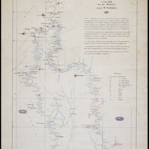
Kaart van de Djelej- en Kotawaringin-rivieren
1881
Indonesia
Map of an expedition exploring two rivers and their tributaries in southern Borneo. Villages and farms are marked (in red for Malay people; in black for Dayak people). Red numbers show height above sea-level in meters; black numbers show latitude.
![](https://historicalmaps.yale-nus.edu.sg/rails/active_storage/representations/eyJfcmFpbHMiOnsibWVzc2FnZSI6IkJBaHBBdDhEIiwiZXhwIjpudWxsLCJwdXIiOiJibG9iX2lkIn19--ca9792f279c433af3709ae8c7519083fe1019237/eyJfcmFpbHMiOnsibWVzc2FnZSI6IkJBaDdCam9MY21WemFYcGxTU0lNTkRBd2VETXdNQVk2QmtWVSIsImV4cCI6bnVsbCwicHVyIjoidmFyaWF0aW9uIn19--bc467f5637e8b6d3bfb826116f92b6bfedfbf03a/leiden-2011323.jpeg)
Nederlandsch Oost-Indië
1865
Brunei, Cambodia, East Timor, Indonesia, Laos, Malaysia, Myanmar, Vietnam, Thailand, Southeast Asia, Singapore, Philippines, Papua New Guinea
This detailed map of the Dutch East Indies in the mid-19th century contains a great deal of information: topographical details, settlements and administrative areas, roads, railways and maritime routes, telegraph lines, inset maps etc.
![](https://historicalmaps.yale-nus.edu.sg/rails/active_storage/representations/eyJfcmFpbHMiOnsibWVzc2FnZSI6IkJBaHBUZz09IiwiZXhwIjpudWxsLCJwdXIiOiJibG9iX2lkIn19--e5abbdcf798d38ab0aeb483c65d3306cb8949795/eyJfcmFpbHMiOnsibWVzc2FnZSI6IkJBaDdCam9MY21WemFYcGxTU0lNTkRBd2VETXdNQVk2QmtWVSIsImV4cCI6bnVsbCwicHVyIjoidmFyaWF0aW9uIn19--bc467f5637e8b6d3bfb826116f92b6bfedfbf03a/bodleian-0464.jpeg)
Algemeene Atlas van Nederlandsche Indie
c.1853-1862
Indonesia
Atlas featuring over 60 detailed maps of the Dutch East Indies: 24 maps cover Java; the remainder cover the rest of the Dutch East Indies. There are three index maps. (All the maps in this atlas are also presented separately on this platform.)
![](https://historicalmaps.yale-nus.edu.sg/rails/active_storage/representations/eyJfcmFpbHMiOnsibWVzc2FnZSI6IkJBaHBBandGIiwiZXhwIjpudWxsLCJwdXIiOiJibG9iX2lkIn19--4f4dfab1357e3ed63eaa6017c1f59a7f40709a25/eyJfcmFpbHMiOnsibWVzc2FnZSI6IkJBaDdCam9MY21WemFYcGxTU0lNTkRBd2VETXdNQVk2QmtWVSIsImV4cCI6bnVsbCwicHVyIjoidmFyaWF0aW9uIn19--bc467f5637e8b6d3bfb826116f92b6bfedfbf03a/beinecke-15249886.jpeg)
Borneo
1851
Malaysia, Southeast Asia, Philippines, East Timor, Vietnam, Brunei, Indonesia
Map of Borneo—with insets of Southeast Asia, Sarawak and Labuan—featuring temperature data, volcanoes, English colonial territory, products of Borneo, geology (rock types), bathymetry (sea depth) and elevations (side views of mountains with heights).
![](https://historicalmaps.yale-nus.edu.sg/rails/active_storage/representations/eyJfcmFpbHMiOnsibWVzc2FnZSI6IkJBaHBBcHdEIiwiZXhwIjpudWxsLCJwdXIiOiJibG9iX2lkIn19--c285870d5ef21e6cfb16375e4de1e6301fe13c06/eyJfcmFpbHMiOnsibWVzc2FnZSI6IkJBaDdCam9MY21WemFYcGxTU0lNTkRBd2VETXdNQVk2QmtWVSIsImV4cCI6bnVsbCwicHVyIjoidmFyaWF0aW9uIn19--bc467f5637e8b6d3bfb826116f92b6bfedfbf03a/bodleian-0051.jpeg)
Borneo
1851
Malaysia, Southeast Asia, Philippines, East Timor, Vietnam, Indonesia, Brunei
Map of Borneo—with insets of Southeast Asia, Sarawak and Labuan—featuring temperature data, volcanoes, English colonial territory, products of Borneo, geology (rock types), bathymetry (sea depth) and elevations (side views of mountains with heights).
![](https://historicalmaps.yale-nus.edu.sg/rails/active_storage/representations/eyJfcmFpbHMiOnsibWVzc2FnZSI6IkJBaHBBa0FCIiwiZXhwIjpudWxsLCJwdXIiOiJibG9iX2lkIn19--83181fd010200745d492981948f88017688b91ce/eyJfcmFpbHMiOnsibWVzc2FnZSI6IkJBaDdCam9MY21WemFYcGxTU0lNTkRBd2VETXdNQVk2QmtWVSIsImV4cCI6bnVsbCwicHVyIjoidmFyaWF0aW9uIn19--bc467f5637e8b6d3bfb826116f92b6bfedfbf03a/leiden-000102.jpeg)
Carte générale des possessions néerlandaises aux Indes orientales
1846
Brunei, East Timor, Indonesia, Malaysia, Philippines, Singapore
Map of the Asian colonial possessions of the Netherlands (Dutch East Indies), with an inset of the heights of some of the region’s mountains. A note describes the average temperature, barometer reading and magnetic declination in Batavia at the time.
- Indonesia21
- Malaysia15
- Brunei12
- East Timor12
- Philippines10
- Singapore10
- Southeast Asia5
- Vietnam5
- Cambodia2
- Laos2
- Myanmar2
- Thailand2
- more Simple Location »
- [remove]Borneo21
- Dutch East Indies19
- Java13
- Sumatra13
- Celebes12
- Sulawesi12
- Maluku Islands11
- South China Sea11
- Western New Guinea11
- Malay Peninsula9
- Celebes Sea7
- East Indies6
- more Detailed Location »
- Cemetery/Columbarium6
- Kampong/Village6
- Military Barracks6
- Military Fort6
- Hospital5
- Church4
- Residential Area4
- Jail/Prison3
- Public Space3
- Temple3
- Communal Land/Property2
- Court of Law2
- Palace2
- Post Office2
- more Settlement Features »
- [remove]District/Administrative Border21
- Colonial Possessions16
- Civic/Metropolitan Border6
- National Border2
- Regional Border1
- [remove]Mountain/Volcano21
- Wetlands7
- Jungle/Wooded Area4
- Wild Animals1
- [remove]Written Note/Details21
- Longitude and Latitude20
- Scale20
- Contour Lines/Elevation17
- Compass Rose3
- Melvill van Carnbee, Pieter6
- Derfelden van Hinderstein, Gijsbert Franco von2
- Mieling, Carl Wilhelm2
- Petermann, August Heinrich2
- Brué, Adrien Hubert1
- Böhm1
- Cronenberg, F.1
- Eckstein, Charles1
- more Map Maker »
- Topographische Bureau5
- Carl Wilhelm Mieling3
- Topographische Inrichting2
- A.J. Bogaerts1
- Baldwin & Cradock1
- Charles Knight & Co.1
- D. Heyse1
- Departement van Koloniën1
- more Printer/Publisher »