Search

Search Results

De stad Batavia met derzelver omstreken: Geteekend in 1826

event1898

location_onIndonesia

The city of Batavia (Jakarta) with its port and castle is to the north (right side of the map). Koningsplein (Merdeka Square), a large area of rice paddies, graveyards and villages can be seen to the south (left). Copied from a c.1826 map.

Plattegrond der stad Batavia

event1866

location_onIndonesia

A mid-19th century map of the important port of Batavia (Jakarta), with its pier, commercial centre and residential streets. However, the city is also surrounded by villages (kampongs), fields and plantations. An inset map shows Batavia Castle.

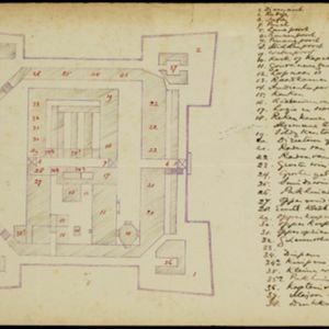
[Plattegrond van kasteel te Batavia]

event1800

location_onIndonesia

Hand-drawn floor plan of Batavia Castle (Jakarta, Java), with a detailed legend identifying many locations within the castle walls, including a church/chapel, storage areas, offices, gates and towers.

close

  • Filter from 1800 to 1898

Current results range from 1800 to 1898