
Search Results


Plan topographique de l'arrondissement de Bien-Hoa
1881
Vietnam
Two-sheet map of the district of Bien-Hoa (Biên Hòa) east of Ho Chi Minh City, Vietnam. The area is dominated by rivers, wetlands and mangroves. Labels describe the terrain e.g. ‘Bois marécageux avec rivières [Swampy woods with rivers]’.

Algemeene kaart van Nederlandsch Indië
1879
Cambodia, Indonesia, Papua New Guinea, East Timor, Southeast Asia, Thailand, Malaysia, Philippines, Laos, Vietnam, Singapore, Brunei, Myanmar
A late 19th century map of the Dutch East Indies on four sheets, detailing maritime routes around the region. There are also inset maps showing railways, rivers, roads, and telegraph systems, as well as individual islands and cities.

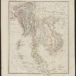
Burmah, Siam and Cochin China
1875
Cambodia, Laos, Malaysia, Myanmar, Thailand, Vietnam
This map of mainland Southeast Asia features short texts noting mines, trade routes and travel times (‘5 to 7 days on Elephants’), history (‘conquered by the King of Siam 1809’), peoples (‘states tributary to the Chinese’) and products (‘Tea Tree’).

Oost-Indie
c.1867
Brunei, Cambodia, East Timor, Indonesia, Laos, Malaysia, Myanmar, Philippines, Singapore, Southeast Asia, Thailand, Vietnam
Map of the East Indies in the mid-19th century, with Dutch colonial territory (Dutch East Indies) coloured in brown. Dutch administrative regions—such as residencies (‘residentie’) and governorates (‘gouvernement’)—are labelled.

Nederlandsch Oost-Indië
1865
Brunei, Cambodia, East Timor, Indonesia, Laos, Malaysia, Myanmar, Vietnam, Thailand, Southeast Asia, Singapore, Philippines, Papua New Guinea
This detailed map of the Dutch East Indies in the mid-19th century contains a great deal of information: topographical details, settlements and administrative areas, roads, railways and maritime routes, telegraph lines, inset maps etc.

Borneo
1851
Malaysia, Southeast Asia, Philippines, East Timor, Vietnam, Brunei, Indonesia
Map of Borneo—with insets of Southeast Asia, Sarawak and Labuan—featuring temperature data, volcanoes, English colonial territory, products of Borneo, geology (rock types), bathymetry (sea depth) and elevations (side views of mountains with heights).

Borneo
1851
Malaysia, Southeast Asia, Philippines, East Timor, Vietnam, Indonesia, Brunei
Map of Borneo—with insets of Southeast Asia, Sarawak and Labuan—featuring temperature data, volcanoes, English colonial territory, products of Borneo, geology (rock types), bathymetry (sea depth) and elevations (side views of mountains with heights).
Hinter Indien
1845
Indonesia, Singapore, Malaysia, Thailand, Vietnam, Myanmar, Laos, Cambodia
A mid-19th century German map of mainland Southeast Asia showing a mixture of ancient kingdoms (e.g. Cochin-China), administrative districts (Malay States) and colonial possessions (Straits Settlements). Extensive mountainous areas are also featured.
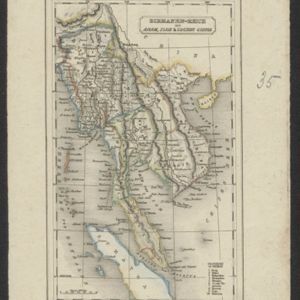
Birmanen Reich mit Anam, Siam & Cochin China
c.1840
Cambodia, Indonesia, Laos, Malaysia, Myanmar, Singapore, Thailand, Vietnam
This mid-19th century map of mainland Southeast Asia is divided into regions with colour-coded borders. The Birman Empire/Birmah (Myanmar) is the most detailed, with 10 provinces marked and listed in the map’s legend.
- [remove]Vietnam36
- Malaysia23
- Cambodia22
- Thailand22
- Indonesia21
- Laos21
- Myanmar20
- Singapore19
- Southeast Asia15
- Brunei14
- Philippines14
- East Timor13
- more Simple Location »
- [remove]District/Administrative Border36
- Regional Border14
- Colonial Possessions12
- National Border9
- Civic/Metropolitan Border5


