
Search Results
Filter
Map Attributes
Contour Lines/Elevation
Remove constraint Map Attributes: Contour Lines/Elevation
Place of Publication
Amsterdam
Remove constraint Place of Publication: Amsterdam
Settlement Features
Kampong/Village
Remove constraint Settlement Features: Kampong/Village
Settlement Features
Residential Area
Remove constraint Settlement Features: Residential Area
8 Results found


Algemeene kaart van Nederlandsch Indië
1879
Cambodia, Indonesia, Papua New Guinea, East Timor, Southeast Asia, Thailand, Malaysia, Philippines, Laos, Vietnam, Singapore, Brunei, Myanmar
A late 19th century map of the Dutch East Indies on four sheets, detailing maritime routes around the region. There are also inset maps showing railways, rivers, roads, and telegraph systems, as well as individual islands and cities.


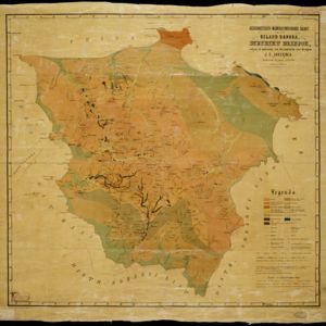
Geognostisch-mijnbouwkundige kaart van het eiland Bangka, distrikt Blinjoe
1872
Indonesia
A geological map showing the types of rock and minerals found in Blinjoe district on the island of Bangka, off the east coast of Sumatra. Deposits of iron, quartz and tin are marked, and coral is shown at the coast.


- [remove]Kampong/Village8
- [remove]Residential Area8
- Military Fort7
- Hospital5
- Cemetery/Columbarium4
- Post Office4
- Church3
- Court of Law3
- Palace3
- Public Space3
- Jail/Prison2
- Military Barracks1
- [remove]Contour Lines/Elevation8
- Scale8
- Longitude and Latitude6
- Compass Rose3
- Written Note/Details2


