
Search Results
4 Results found


Algemeene kaart van Nederlandsch Oostindie
c.1839-1855
East Timor, Indonesia, Malaysia, Singapore
This map of the Dutch East Indies is spread over eight sheets, with a hand-drawn cover sheet showing the whole area. There are numerous inset maps of islands, bays, cities etc. Two of the inset maps have a replacement map pasted over them.
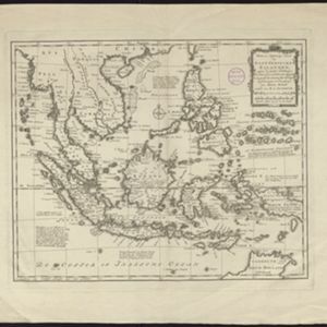
Nieuwe en naukeurige kaart der Oost-Indische Eilanden
c.1770
Brunei, Cambodia, East Timor, Indonesia, Laos, Malaysia, Myanmar, Philippines, Singapore, Southeast Asia, Thailand, Vietnam
Some regions on this map of Southeast have a descriptive label: Sumatra is described as having mines of gold, silver, iron, and sulphur; and elephants, tigers, rhinoceroses, dragons and crocodiles. Gilolo has rice, sago and turtles. Ambon has nutmeg.
- Filter from 1770 to 1842
- Ambon4
- Borneo4
- Celebes4
- [remove]Halmahera4
- Java4
- Malay Peninsula4
- [remove]Maluku Islands4
- Sulawesi4
- Sumatra4
- Western New Guinea4
- Amboina2
- Amboyna2
- more Detailed Location »
- [remove]Colonial Possessions4
- Civic/Metropolitan Border2
- District/Administrative Border2
- Regional Border2


