
Search Results


Kaart van de residentie Oostkust van Sumatra
1889
Indonesia
Detailed topographical map of the east coast of Sumatra, spread over 34 sheets. The area’s farms are listed and shown on the map, with types of crop grown. With five inset maps of individual towns. Two sheets and the cover sheet are missing.


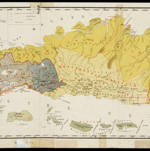
Kaart van de residentie Oostkust van Sumatra
1889
Indonesia
Detailed topographical map of the east coast of Sumatra, spread over 36 sheets plus a cover sheet of the whole area. Mountains and forests dominate, with villages, routes and administrative borders shown. With five inset maps of individual towns.


Schetskaart der afdeeling Westkust van Atjeh
1888
Indonesia
From a Dutch geographical society journal, this map of the west coast of Atjeh (Aceh), Sumatra, shows shoals, reefs, bathymetry (sea depth) and anchor points. On land, there are mountains (with heights), rivers, pepper plantations and rice fields.

Malay, or East Indian Archipelago, with Burmah, Siam &c.
1887
Brunei, Cambodia, East Timor, Indonesia, Laos, Malaysia, Myanmar, Philippines, Singapore, Southeast Asia, Thailand, Vietnam
On this map of Southeast Asia, numerous small islands, shoals and reefs are marked and named, especially in the South China Sea and around the Sunda and Maluku islands. Submarine cables to carry telegraph messages around the region are also shown.

Kaart van de Afdeeling Deli der residentie Oostkust van Sumatra
1887
Indonesia
A map of the department of Deli, Java, divided into administrative districts, and spread over eight sheets. Rivers, railways, roads and paths, forests and mountains, and crops—rice, coconut, pepper, nutmeg, alang-alang—are marked.

India, Burmah and the adjacent parts of Beluchistan, Afghanistan, Turkestan, the Chinese Empire, and Siam
1887
Myanmar, Thailand, Malaysia, Indonesia
British Burma is shown on the right of this two-sheet map of India. The green areas had come under British rule after the first and second Anglo-Burmese wars, with Upper Burma (light brown) being incorporated after the Third Anglo-Burmese War (1885).


A sketch map of the East Indian possessions of the Netherlands
1886
Brunei, Indonesia, Malaysia, Papua New Guinea, Philippines, Singapore
Produced by the Intelligence Branch of the British War Office, this map shows Dutch colonial territories in maritime Southeast Asia, and their political and military divisions in Java and Madura. British and Spanish territories are also marked.
- Filter from 1535 to 1900
- Indonesia748
- Malaysia640
- Singapore615
- Brunei568
- Thailand566
- Cambodia545
- Vietnam531
- Myanmar530
- Philippines521
- Laos503
- East Timor493
- Southeast Asia482
- more Simple Location »
- [remove]Sumatra752
- Borneo590
- Java573
- Malay Peninsula495
- Sulawesi469
- Celebes402
- Western New Guinea321
- Maluku Islands302
- Siam300
- Sunda Islands251
- Malacca232
- Pegu224
- more Detailed Location »
- Cartouche324
- Illustration233
- Legend159
- Inset Map138
- Coat of Arms63
- Elevation38
- [remove]Longitude and Latitude752
- Scale448
- Compass Rose229
- Written Note/Details178
- Contour Lines/Elevation167
- Rhumbline Network73


