
Search Results
Filter
Map Attributes
Scale
Remove constraint Map Attributes: Scale
Cultural Regions
Religious Groups
Remove constraint Cultural Regions: Religious Groups
Collections
Beinecke Rare Book and Manuscript Library Yale University
Remove constraint Collections: Beinecke Rare Book and Manuscript Library Yale University
2 Results found

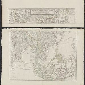
Carte des Indes et de la Chine
1705
Brunei, Cambodia, East Timor, Indonesia, Laos, Malaysia, Myanmar, Philippines, Southeast Asia, Singapore, Thailand, Vietnam
An early 18th century map of Asia by the French cartographer Guillaume Delisle (1675–1726). Regions are indicated with coloured borders, and the southern part of Borneo is labelled ‘Côte de Mahometans [Coast of the Muslims]’.


