
Search Results
7 Results found


Zuidelijk gedeelte van de Chineesche zee: Blad I
1893
Malaysia, Indonesia, Singapore
Navigation map of the southern part of the South China Sea, including the straits of Malacca and Singapore, and the Riau Archipelago. Bathymetry (sea depth), lighthouses, shoals and other obstructions are marked, with hills to use as landmarks.

Westkust Borneo: Mond der Padang-Tikar rivier
1884
Indonesia
Navigation map of the mouth of the Padang Tikar River, on the west coast of Borneo, featuring bathymetric (water depth) routes. Obstructions are marked with letters: ‘m’ (mud), ‘z’ (sand). Trees, hills and fishermen’s houses are shown as landmarks.
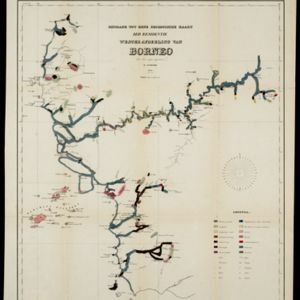
Bijdrage tot eene geologische kaart der residentie Westerafdeeling van Borneo
1858
Indonesia
A geological map of western Borneo made by a mine engineer, showing the types of soil, coal, clay, and rock (limestone, sandstone, granite, basalt), as well as gold, diamonds, tin, copper and iron found along the rivers.
- [remove]Compass Rose7
- [remove]Longitude and Latitude7
- Scale7
- Contour Lines/Elevation6
- Written Note/Details2


