
Search Results
14 Results found


Insulae Iavae Pars Occidentalis / Insulae Iavae Pars Orientalis
c.1720
Indonesia
A map of Java with mountains, jungles, animals and crops. Bathymetry (sea depth) is marked, including on an inset map of Batavia harbour. Illustrations include Batavia Castle, and a lion—representing Belgium—receiving tribute and enslaving locals.

Insulae Iavae pars Occidentalis
c.1710-1719
Indonesia
A map of Java with mountains, jungles, animals and crops. Bathymetry (sea depth) is marked, including on an inset map of Batavia harbour. Illustrations include Batavia Castle, and a lion—representing Belgium—receiving tribute and enslaving locals.


Insularum Indiæ orientalis nova descriptio
c.1700
Brunei, Cambodia, East Timor, Indonesia, Laos, Malaysia, Myanmar, Philippines, Singapore, Southeast Asia, Thailand, Vietnam
The outline of the island of New Guinea is very vague on this early 17th century map of Southeast Asia. The cartouche is decorated with two figures of Asian warriors: one holds a spear, the other a sword. There are also drawings of mermaids.
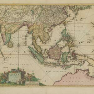
Indiae orientalis, nec non insularum adiacentium
1698
Myanmar, Philippines, Singapore, Southeast Asia, Thailand, Vietnam, Malaysia, Laos, Indonesia, East Timor, Cambodia, Brunei
The cartouche on this map of Asia is decorated with a colourful painting illustrating the region’s commerce, with Asian merchants displaying an assortment of goods, including jewellery, porcelain vessels and figurines, textiles and exotic animals.
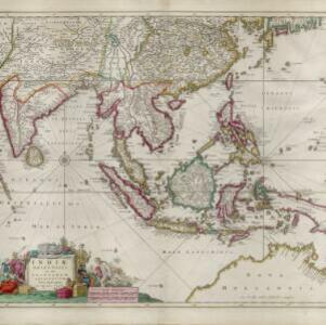
Indiæ Orientalis nec non Insularum Adiacentium Nova Descriptio
1685
Brunei, Cambodia, East Timor, Indonesia, Laos, Malaysia, Myanmar, Philippines, Singapore, Southeast Asia, Thailand, Vietnam
The cartouche on this map of Asia is decorated with a colourful painting illustrating the region’s commerce, with Asian merchants displaying an assortment of goods, including jewellery, porcelain vessels and figurines, textiles and exotic animals.
- [remove]Compass Rose14
- Longitude and Latitude14
- [remove]Rhumbline Network14
- [remove]Scale14
- Written Note/Details7
- Contour Lines/Elevation2


