
Search Results


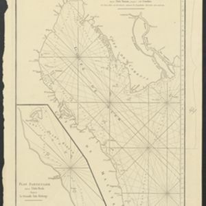
Carte Plate du Golfe de Siam: avec une partie des Côtes de Malaye et de Camboje, depuis l'Isle Timon, jusqu'à celle Condor
1775
Cambodia, Malaysia, Thailand
Map of the Gulf of Siam (Gulf of Thailand) with shoals and small islands marked. The web of lines is a rhumbline network, while the numbers indicate sea depth (bathymetry), both used to aid navigation. There is an inset map of the Redang Archipelago.

Plan de Salangor et de La Cote de Malaye: depuis la Pointe de Caran jusqu'au Mont Parcelar
1775
Malaysia
Map of the coast of Selangor on the west of the Malay Peninsula. The web of lines is a rhumbline network, the numbers indicate sea depth (bathymetry), and there are drawings of the side views of mountains (elevations), all to aid navigation.
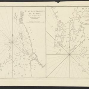
Plan de l'Archipel de Merguy / Plan de l'Isle Junkseilon
1775
Myanmar, Thailand
Two coastal navigation maps: one of the Mergui Archipelago off the west coast of Myanmar; and one of Phuket (‘Isle Junkseilon’) and the surrounding islands off the west coast of Thailand. Both feature bathymetry (sea depth), shoals and reefs.

Carte Plate du Golfe de Siam: avec une partie des Côtes de Malaye et de Camboje, depuis l'Isle Timon, jusqu'à celle Condor
1775
Cambodia, Malaysia, Thailand
Map of the Gulf of Siam (Gulf of Thailand) with shoals and small islands marked. The web of lines is a rhumbline network, while the numbers indicate sea depth (bathymetry), both used to aid navigation. There is an inset map of the Redang Archipelago.
Plan de Salangor et de La Cote de Malaye: depuis la Pointe de Caran jusqu'au Mont Parcelar
1775
Malaysia
Map of the coast of Selangor on the west of the Malay Peninsula. The web of lines is a rhumbline network, the numbers indicate sea depth (bathymetry), and there are drawings of the side views of mountains (elevations), all to aid navigation.
Plan de l'Archipel de Merguy / Plan de l'Isle Junkseilon
1775
Myanmar, Thailand
Two coastal navigation maps: one of the Mergui Archipelago off the west coast of Myanmar; and one of Phuket (‘Isle Junkseilon’) and the surrounding islands off the west coast of Thailand. Both feature bathymetry (sea depth), shoals and reefs.


Plan de la ville et forteresse de Malaca: pour servir à l'histoire generale des voyages
1750
Malaysia
This mid-18th century plan of the city of Malaca (Malacca/Melaka) focuses on the military fort (‘A Famosa [The Famous]’), but also includes two churches, a mosque and a Chinese temple. Two markets are also marked, as is the entrance to the port.


