
Search Results


New sketch map of the protected Malay State of Perak
1892
Malaysia
Map of state of Perak (Malay Peninsula) with a table of statistics: area, population, road/railway/river lengths, revenue, tin exports. Straits Settlements highlighted red. Someone has added handwritten travel times/distances by steamer/road/train.

Nederlandsch Oost-Indië
1865
Brunei, Cambodia, East Timor, Indonesia, Laos, Malaysia, Myanmar, Vietnam, Thailand, Southeast Asia, Singapore, Philippines, Papua New Guinea
This detailed map of the Dutch East Indies in the mid-19th century contains a great deal of information: topographical details, settlements and administrative areas, roads, railways and maritime routes, telegraph lines, inset maps etc.

Map of Prince of Wales' Island or Pulo Penang and province Wellesley
1853
Malaysia
Map of the Penang Strait, including written instructions on how to navigate the strait. On land, areas of cultivation are marked, with a table listing acreage used for each crop. A boundary with Siam based on an 1831 treaty is also shown.


Algemeene kaart van Nederlandsch Oostindie
c.1839-1855
East Timor, Indonesia, Malaysia, Singapore
This map of the Dutch East Indies is spread over eight sheets, with a hand-drawn cover sheet showing the whole area. There are numerous inset maps of islands, bays, cities etc. Two of the inset maps have a replacement map pasted over them.
To James Carnegy and Robert Scott Esqrs. of Prince of Wales Island... this Chart of the Islands and Channels at the Southwest Extremity of the China Sea
1824
Malaysia, Singapore, Indonesia
Chart of the Singapore Strait, Riau Archipelago and Lingga Islands, marked with bathymetry (sea depth), side views of landmark mountains (elevations), written notes, and islands, shoals and reefs, all to aid navigation.

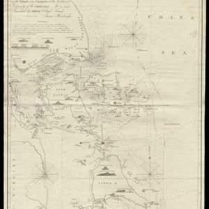
A plan of soundings from Pulo Aor to the Southward, and outside of the Reef off Point Romania towards the entrance of Sincapour Strait
1818
Malaysia, Indonesia, Singapore
Navigation chart of part of the South China Sea leading to the eastern entrance of the Singapore Strait. Features bathymetry (sea depth), anchor points, shoals and other obstructions, landmark hills, and detailed explanatory notes.


Plan de Salangor et de La Cote de Malaye: depuis la Pointe de Caran jusqu'au Mont Parcelar
1775
Malaysia
Map of the coast of Selangor on the west of the Malay Peninsula. The web of lines is a rhumbline network, the numbers indicate sea depth (bathymetry), and there are drawings of the side views of mountains (elevations), all to aid navigation.
- Filter from 1595 to 1892
- [remove]Malay Peninsula53
- Sumatra43
- Borneo39
- Java38
- Sulawesi35
- Celebes33
- Malacca31
- Siam30
- Western New Guinea27
- Pegu25
- Maluku Islands21
- Insulae Philippinae19
- more Detailed Location »
- [remove]Compass Rose53
- [remove]Written Note/Details53
- Longitude and Latitude45
- Scale38
- Rhumbline Network17
- Contour Lines/Elevation8


