
Search Results
Filter
Map Attributes
Compass Rose
Remove constraint Map Attributes: Compass Rose
Map Maker
Après de Mannevillette, Jean-Baptiste d'
Remove constraint Map Maker: Après de Mannevillette, Jean-Baptiste d'
Place of Publication
London
Remove constraint Place of Publication: London
Sea Features
Shoal
Remove constraint Sea Features: Shoal
3 Results found

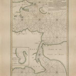
A new plan of the Straits, situated to the east of Java & Madura commonly called the Straits of Bali and of Pondi and Respondi
1794
Indonesia
A late 18th century navigation map of the waters between the islands of Java, Madura and Bali. The web of lines is a rhumbline network, the numbers indicate sea depth (bathymetry), and there is an inset map of the Bay of Ballambouang, Java.

A new chart of the Oriental Seas and Islands... from the Isle of Ceylon to Amoye in China
1790
Brunei, Cambodia, East Timor, Indonesia, Laos, Malaysia, Myanmar, Philippines, Singapore, Southeast Asia, Thailand, Vietnam
A late 18th century maritime map of Southeast Asia, marked with expedition routes including the return of Captain Cook’s HMS Endeavour from Australia in 1770, and Captain Philip Carteret’s circumnavigation expedition in 1768.


