
Search Results


Contrafactur des Scharmutz els der Hollander wider die Portigesen in dem Flus Batusabar
1607
Singapore
Maps can sometimes record a single event: this map depicts an October 1603 battle between the Dutch and Portuguese, as they fought for control of the trade routes through the Singapore Straits. The text panel recounts the story of the battle.


Nova tabula insularum Iavae, Sumatrae, Borneonis et aliarum Mallaccam usquae
1601
Malaysia, Indonesia, Singapore
Adapted by Theodore de Bry from an original by Willem Lodewycksz, this map has some inaccuracies e.g. the Malay Peninsula (‘Chersonese’) is completely bisected by the Muar River, leaving the southern tip of the peninsula as a separate island.
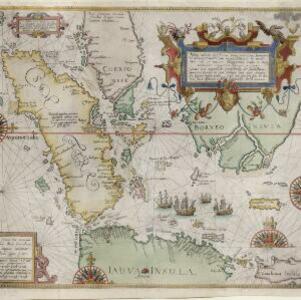
Nova tabula insularum Iavae, Sumatrae, Borneonis et aliarum Mallaccam usquae
1598
Malaysia, Indonesia, Singapore
Adapted by Theodore de Bry from an original by Willem Lodewycksz, this map has some inaccuracies e.g. the Malay Peninsula (‘Chersonese’) is completely bisected by the Muar River, leaving the southern tip of the peninsula as a separate island.


