
Search Results


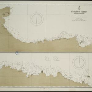
Noordkust Celebes: Hoek Kandi tot hoek Dondo
1899
Indonesia
Two navigation maps for the north coast of Celebes (Sulawesi), featuring bathymetry (sea depth), landmark mountains, reefs and shoals. Obstructions in the water are marked ‘kr’ (coral), ‘m’ (mud), ‘s’ (shells), ‘st’ (stones), and ‘z’ (sand).


Noordkust Celebes: Hoek Samija tot hoek Doelang
1899
Indonesia
A navigation map for the north coast of Celebes (Sulawesi), featuring bathymetry (sea depth), reefs and shoals. Obstructions in the water are marked ‘kr’ (coral), ‘m’ (mud), ‘st’ (stones), and ‘z’ (sand). Five additional maps show details of rivers.

Riouw archipel: Straat Doerian en oostelijke vaarwaters
1899
Indonesia
Navigation map of the waters and straits around some of the islands of the Riau Archipelago, between Sumatra and Batam. Bathymetry (sea depth), current and tide data, reefs, shoals and other obstructions (clay, mud, shells, stones, sand) are marked.

Vaarwaters en ankerplaatsen op de oostkust van Borneo: Blad III
1899
Indonesia
Navigation maps of two bays on the southeast coast of Borneo. Anchorages, bathymetry (sea depth), buoys, shoals and other obstructions are shown. There is an inset map of the roadstead—a body of water sheltered from tides/currents—at Balikpapan Bay.

Zuidelijk gedeelte van de Chineesche zee: Blad I
1899
Malaysia, Singapore, Indonesia
Navigation map of the southern part of the South China Sea, including the straits of Malacca and Singapore, and the Riau Archipelago. Bathymetry (sea depth), lighthouses, shoals and other obstructions are marked, with hills to use as landmarks.

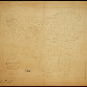
Caart eeniger ryken gelegen op het eyland Groot Java bestaande in het Koningryk Jaccatra de regentschappen Tjanjoer, Bandong, Timbanganten en Batoelejan als mede een gedeelte van Parrakkanmoentjang en Crawang
1898
Indonesia
A hand-drawn late 19th century map of western Java, divided into regencies. The map is orientated with south at the top so that Batavia, on the northern coast of Java, is at the bottom of the map.

Copie no. 2: Plan van den stadt en het casteel van Batavia met een gedeeltevan deszelfs voorsteeden en verdere buijtenplaatse ao 1762
1898
Indonesia
A hand-drawn and coloured plan of the important port city of Batavia (Jakarta), with a detailed legend identifying parts of the city, castle and suburbs. Handwritten notes around the border give the names of roads. Copied from a 1764 map.

Kaart van het kasteel en de stad Batavia in het jaar 1667
1898
Indonesia
Very detailed map of the port city of Batavia (Jakarta), with numerous locations listed in the multiple legends. The city’s coat of arms—featuring a sword and laurel wreath—and the Dutch East India Company monogram logo—letters ‘VOC’—are also shown.
- Filter from 1595 to 1899
- [remove]Compass Rose174
- Scale152
- Longitude and Latitude128
- Contour Lines/Elevation42
- Rhumbline Network36
- Written Note/Details29


