
Search Results


Partie de la nouvelle grande carte des Indes Orientales, contenant les isles Maldives, Ceylan, Malacca, Sumatra... les isles de Borneo, Iava, Celebes, Mindanao
c.1750
Brunei, East Timor, Indonesia, Malaysia, Papua New Guinea, Philippines, Singapore
Map of maritime Southeast Asia, with mountains, forests and settlements represented pictorially. The lower part of the map, which had six inset maps, has been cut off and is missing.

Partie de la nouvelle grande carte des Indes Orientales, contenant les isles Maldives, Ceylan, Malacca, Sumatra... les isles de Borneo, Iava, Celebes, Mindanao
c.1750
Brunei, East Timor, Indonesia, Malaysia, Papua New Guinea, Philippines, Singapore
Map of maritime Southeast Asia, with four inset maps of locations in the region: Surabaya, some of the Lesser Sumba Islands, and Buton and Muna islands of the coast of Sulawesi. Mountains, forests, settlements and fields are represented pictorially.

Carte des Indes Orientalis
1748
Brunei, Cambodia, East Timor, Indonesia, Laos, Malaysia, Myanmar, Philippines, Singapore, Southeast Asia, Vietnam, Thailand
This mid-18th century map features labels noting the local populations, including the Kemois of the mountains and deserts of Cochinchinae (Vietnam) and the Byayos of Borneo. The map’s cartouche is embellished with maritime and military paraphernalia.

Carte des Indes Orientales: 2de. feuille
1748
Brunei, East Timor, Indonesia, Malaysia, Philippines, Vietnam
This map features a label noting that the Byayos people inhabited the mountains of central Borneo. Another note at the northeast tip of Borneo states that the location and number of islands in the area is uncertain. Sheet two of two.
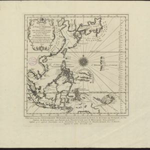

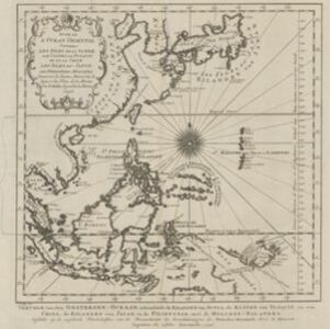
Carte des Indes Orientales
1748
Brunei, Cambodia, East Timor, Indonesia, Laos, Malaysia, Myanmar, Philippines, Singapore, Southeast Asia, Thailand, Vietnam
This mid-18th century map features a label noting that the Byayos people inhabited the mountains of central Borneo. Another note at the northeast tip of Borneo states that the location and number of islands in the area is uncertain.

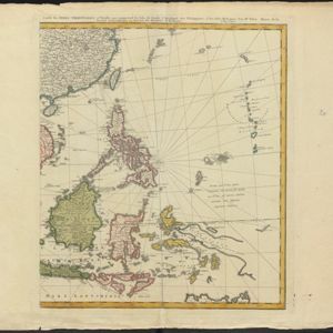
Suite de l'Ocean Oriental contenant les Isles de la Sonde, les costes de Tunquin et de la Chine, les isles du Japon, les Philippines, Moluques
1746
Brunei, Cambodia, East Timor, Indonesia, Malaysia, Papua New Guinea, Philippines, Singapore, Southeast Asia, Thailand, Vietnam
The coast of New Guinea (‘Nova Guinéa’) is represented in part by a dotted line on this mid-18th century map, indicating that the exact coastlines were unknown at this time. Originally in French, the map has been modified to add Dutch text as well.


