
Search Results

La nouvelle grande carte des Indes Orientales
1792
Cambodia, Laos, Myanmar, Philippines, Thailand, Vietnam
Map of mainland Southeast Asia divided into kingdoms. Larger settlements are marked pictorially with a red building symbol. The desert of Cochinchine (Vietnam) is labelled as being inhabited by the ‘Kemoys Peuples Barbares [Kemoys Barbarian People]’.
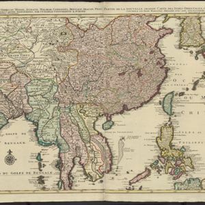

Carte du Détroit de la Sonde, depuis la pointe de Winerou jusques à l'Isle du Nord
c.1790
Indonesia
Navigation chart of the Sunda Strait, focusing on bays and islands, and showing bathymetry (sea depth), anchor points, shoals and reefs. Includes an inset map of the bay of the Isle de Mew (Peucang Island). The web of lines is a rhumbline network.


Carte de la Côte de Pégou, et de celle de Martaban
1775
Myanmar
Navigation map of the coast of the ancient kingdom of Pégou and near the town of Martaban (Mottama), Myanmar. Bathymetry (sea depth), anchor points, notes on currents and obstructions are marked, and there are drawings of side views of coastal hills.

Carte de la Côte Orientale du Golfe De Bengale
1775
Myanmar
Although mainly of India, this map of the Gulf of Bengal includes maritime routes near the west coast of Burma (Myanmar). The web of lines is a rhumbline network, while the numbers indicate sea depth (bathymetry), both used to aid navigation.


