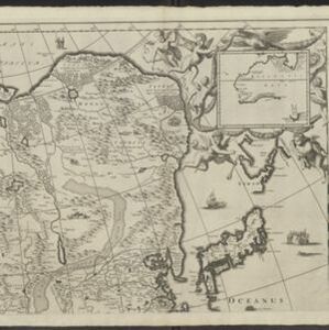
Descriptio hydrographica accommodata ad battavorum navagatione in Javam insulam Indiæ Orientalis
c.1599-1628
Brunei, Cambodia, East Timor, Indonesia, Laos, Malaysia, Myanmar, Philippines, Singapore, Southeast Asia, Thailand, Vietnam
This map shows the route of the first Dutch expedition to Southeast Asia in 1595-7. Led by Cornelis de Houtman, it was an attempt to enter the spice trade. The route crosses east over the Indian Ocean, circles the island of Java, and returns west.