
Search Results
12 Results found


Reduzirte Karte vom Sunda- oder Borneo-Meere
1835
Malaysia, Indonesia
A navigation map of the Java Sea and Sunda Islands, with bathymetry (sea depth), maritime routes, shoals and reefs, and elevations (side views of terrestrial landmarks). Inset maps feature the bay at Batavia and the straits between the Sunda Islands.

Algemeene kaart van Nederlandsch Oostindie
c.1839-1855
East Timor, Indonesia, Malaysia, Singapore
This map of the Dutch East Indies is spread over eight sheets, with a hand-drawn cover sheet showing the whole area. There are numerous inset maps of islands, bays, cities etc. Two of the inset maps have a replacement map pasted over them.


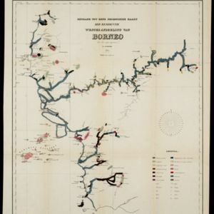
Bijdrage tot eene geologische kaart der residentie Westerafdeeling van Borneo
1858
Indonesia
A geological map of western Borneo made by a mine engineer, showing the types of soil, coal, clay, and rock (limestone, sandstone, granite, basalt), as well as gold, diamonds, tin, copper and iron found along the rivers.

Nederlandsch Oost-Indië
1865
Brunei, Cambodia, East Timor, Indonesia, Laos, Malaysia, Myanmar, Vietnam, Thailand, Southeast Asia, Singapore, Philippines, Papua New Guinea
This detailed map of the Dutch East Indies in the mid-19th century contains a great deal of information: topographical details, settlements and administrative areas, roads, railways and maritime routes, telegraph lines, inset maps etc.

Schetskaart der afdeeling Westkust van Atjeh
1888
Indonesia
From a Dutch geographical society journal, this map of the west coast of Atjeh (Aceh), Sumatra, shows shoals, reefs, bathymetry (sea depth) and anchor points. On land, there are mountains (with heights), rivers, pepper plantations and rice fields.
- Filter from 1798 to 1888
- [remove]District/Administrative Border12
- Civic/Metropolitan Border7
- Colonial Possessions3
- National Border1


