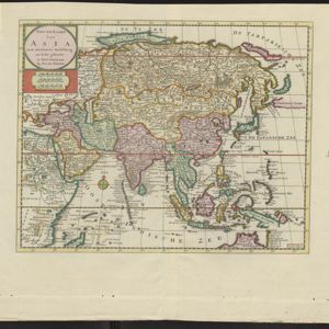
Nieuwe kaart van Asia na de alderlaatste ondekking int licht gebracht
1733
Brunei, Cambodia, East Timor, Indonesia, Laos, Malaysia, Myanmar, Papua New Guinea, Philippines, Singapore, Southeast Asia, Thailand, Vietnam
Map of Asia showing New Guinea (‘Nieuw Guinee’) and Australia (‘Nieuw Holland’) as one landmass, demonstrating that there was some uncertainty about the area’s geography in the early 18th century. However, it does include New Britain (‘N. Bretanje’).