
Search Results


[Dutch portolan chart of the island of Madura]
c.1700
Indonesia
Colourful hand-drawn portolan (nautical) navigation chart, featuring bathymetry (sea depth), shoals and reefs, and anchor points. The coasts have pictorial representations of landmarks (trees, houses, mountains). Orientated with south at the top.

[Dutch Portolan chart of the Java Sea]
c.1700
Indonesia
Hand-drawn portolan (nautical) chart, featuring a rhumbline network (the web of interconnected lines), bathymetry (sea depth), shoals and reefs, elevations (side views of landmark mountains), and names of coastal settlements, all to aid navigation.

A new mapp of Asia: divided into kingdoms & provinces
1690
Brunei, Cambodia, East Timor, Indonesia, Laos, Malaysia, Myanmar, Philippines, Singapore, Southeast Asia, Thailand, Vietnam
A detailed late 17th century map of Asia, showing ancient kingdoms and the place names of important settlements. The cartouche features a drawing of Asian traders selling their goods, while a camel, monkey and two birds look on.

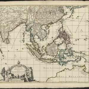
Indiæ Orientalis nec non Insularum Adiacentium Nova Descriptio
1689
Brunei, Cambodia, East Timor, Indonesia, Laos, Malaysia, Myanmar, Philippines, Singapore, Southeast Asia, Thailand, Vietnam
The cartouche on this map of Asia is decorated with a colourful depiction of a European man negotiating with an Asian merchant to buy an assortment of Asian goods, including jewellery, porcelain vessels and figurines, and textiles.

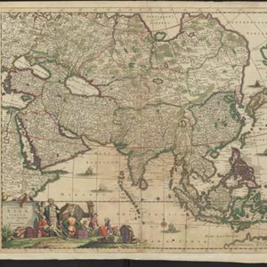
Accuratissima totius Asiæ tabula: In omnes partes divisa
c.1689-1702
Brunei, Cambodia, East Timor, Indonesia, Laos, Malaysia, Myanmar, Philippines, Singapore, Southeast Asia, Thailand, Vietnam
A detailed late 17th century map of Asia, showing ancient kingdoms and the place names of important settlements. The cartouche features a drawing of Asian traders selling their goods, while a camel, monkey and two birds look on.

Indiæ Orientalis nec non Insularum Adiacentium Nova Descriptio
1685
Brunei, Cambodia, East Timor, Indonesia, Laos, Malaysia, Myanmar, Philippines, Singapore, Southeast Asia, Thailand, Vietnam
The cartouche on this map of Asia is decorated with a colourful painting illustrating the region’s commerce, with Asian merchants displaying an assortment of goods, including jewellery, porcelain vessels and figurines, textiles and exotic animals.

[Chart of the Indian Ocean]
1684
Cambodia, Indonesia, Malaysia, Myanmar, Thailand
Colourful hand-drawn portolan (nautical) navigation chart, featuring a rhumbline network (the web of interconnected lines), islands, shoals and reefs. With an elaborately decorated cartouche, scale and compass roses. Vellum on folding wood boards.
Accuratissima totius Asiæ tabula: Recens emendata
1680
Brunei, Cambodia, East Timor, Indonesia, Laos, Malaysia, Myanmar, Philippines, Singapore, Southeast Asia, Thailand, Vietnam
A detailed late 17th century map of Asia, showing ancient kingdoms and the place names of important settlements. The cartouche features a drawing of Asian traders selling their goods, while a camel, monkey and two birds look on.
Indiæ Orientalis nec non Insularum Adiacentium Nova Descriptio
c.1680
Brunei, Cambodia, East Timor, Indonesia, Laos, Malaysia, Myanmar, Philippines, Singapore, Southeast Asia, Thailand, Vietnam
The cartouche on this map of Asia is decorated with a detailed depiction of a European man negotiating with an Asian merchant to buy an assortment of Asian goods, including jewellery, porcelain vessels and figurines, and textiles.
- Filter from 1599 to 1840
- [remove]Compass Rose72
- Longitude and Latitude67
- Scale39
- Rhumbline Network20
- Written Note/Details12


