Search

Search Results

New Sketch Map of the Protected Malay State of Perak

event1892

location_onMalaysia

Map of the state of Perak (Malay Peninsula) with a table of statistics: area, population, road/railway/river lengths, revenue, tin exports. Gold and tin mines are marked, and the Straits Settlements are highlighted in red.

New sketch map of the protected Malay State of Perak

event1892

location_onMalaysia

Map of state of Perak (Malay Peninsula) with a table of statistics: area, population, road/railway/river lengths, revenue, tin exports. Straits Settlements highlighted red. Someone has added handwritten travel times/distances by steamer/road/train.

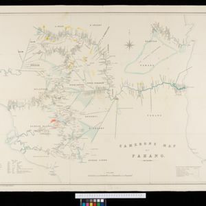
Cameron's map of Pahang

event1889

location_onMalaysia

A map of the Malayan states of Pahang and Selangor, showing the rivers, mines (gold, tin, sulphur, shale) and mining companies in the region. There is also a list translating Malay terms used on the map into English.

close

  • Filter from 1889 to 1892

Current results range from 1889 to 1892