Search

Search Results

Copie no. 2: Plan van den stadt en het casteel van Batavia met een gedeeltevan deszelfs voorsteeden en verdere buijtenplaatse ao 1762

event1898

location_onIndonesia

A hand-drawn and coloured plan of the important port city of Batavia (Jakarta), with a detailed legend identifying parts of the city, castle and suburbs. Handwritten notes around the border give the names of roads. Copied from a 1764 map.

Westkust Celebes: Vaarwaters benoorden Makasser: Blad I

event1898

location_onIndonesia

Navigation map of the west coast of Celebes (Sulawesi), north of Makassar. Bathymetry (sea depth), lighthouses, shoals and other obstructions are marked, with trees and hills as landmarks, and elevations (side views of hills) to aid navigation.

Kaart van het kasteel en de stad Batavia in het jaar 1667

event1898

location_onIndonesia

Very detailed map of the port city of Batavia (Jakarta), with numerous locations listed in the multiple legends. The city’s coat of arms—featuring a sword and laurel wreath—and the Dutch East India Company monogram logo—letters ‘VOC’—are also shown.

Riouw-archipel: Reede Riouw

event1895

location_onIndonesia

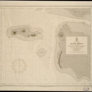
Navigation map of the Riau Roadstead (off west coast of Bintan, Riau Archipelago): a body of water sheltered from tides/currents, for ships to anchor. Bathymetry (sea depth) and various obstructions and landmarks (hills, buildings, trees) are shown.

Moluksche archipel: Baai van Amboina

event1895

location_onIndonesia

A map to aid navigation in Ambon Bay, on the island of Ambon in the Maluku Islands: bathymetry (sea depth) and mountains are shown along the coasts, with inset maps of a coal mine pier and Fort Victoria. A second map updates the coal mine pier map.

New Sketch Map of the Protected Malay State of Perak

event1892

location_onMalaysia

Map of the state of Perak (Malay Peninsula) with a table of statistics: area, population, road/railway/river lengths, revenue, tin exports. Gold and tin mines are marked, and the Straits Settlements are highlighted in red.

New sketch map of the protected Malay State of Perak

event1892

location_onMalaysia

Map of state of Perak (Malay Peninsula) with a table of statistics: area, population, road/railway/river lengths, revenue, tin exports. Straits Settlements highlighted red. Someone has added handwritten travel times/distances by steamer/road/train.

Algemeene kaart van Nederlandsch Indië

event1879

location_onCambodia, Indonesia, Papua New Guinea, East Timor, Southeast Asia, Thailand, Malaysia, Philippines, Laos, Vietnam, Singapore, Brunei, Myanmar

A late 19th century map of the Dutch East Indies on four sheets, detailing maritime routes around the region. There are also inset maps showing railways, rivers, roads, and telegraph systems, as well as individual islands and cities.

Map of the Malay Peninsula 1879

event1879

location_onMalaysia, Singapore, Thailand

Six-sheet map of the Malay Peninsula, featuring settlements, mountains and rivers. Labels note names of indigenous peoples, or describe terrain/resources. There is an inset map of Singapore town, and the Straits Settlements are highlighted in red.

Nederlandsch Oost-Indië

event1865

location_onBrunei, Cambodia, East Timor, Indonesia, Laos, Malaysia, Myanmar, Vietnam, Thailand, Southeast Asia, Singapore, Philippines, Papua New Guinea

This detailed map of the Dutch East Indies in the mid-19th century contains a great deal of information: topographical details, settlements and administrative areas, roads, railways and maritime routes, telegraph lines, inset maps etc.

Reede van Bengkoelen

event1856

location_onIndonesia

Map of the bay at Bengkoelen (Bengkulu, west coast of Sumatra), with bathymetry (sea depth), islands, shoals and reefs marked. Two lighthouses are shown, with lines to indicate the limits of their range.

Reede van Bengkoelen

event1856

location_onIndonesia

Map of the bay at Bengkoelen (Bengkulu, west coast of Sumatra), with bathymetry (sea depth), islands, shoals and reefs marked. Two lighthouses are shown, with lines to indicate the limits of their range.

close