
Search Results


Westkust Celebes: Vaarwaters benoorden Makasser: Blad II
1898
Indonesia
Navigation map of the west coast of Celebes (Sulawesi), north of Makassar. Bathymetry (sea depth), shoals and other obstructions are marked, with hills and settlements as landmarks, and elevations (side views of hills) to aid navigation.

Copie no. 2: Plan van den stadt en het casteel van Batavia met een gedeeltevan deszelfs voorsteeden en verdere buijtenplaatse ao 1762
1898
Indonesia
A hand-drawn and coloured plan of the important port city of Batavia (Jakarta), with a detailed legend identifying parts of the city, castle and suburbs. Handwritten notes around the border give the names of roads. Copied from a 1764 map.
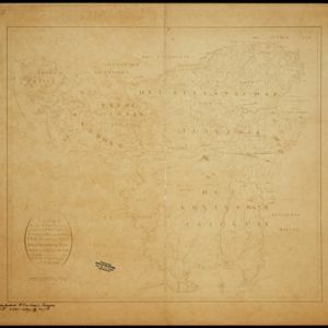
Caart eeniger ryken gelegen op het eyland Groot Java bestaande in het Koningryk Jaccatra de regentschappen Tjanjoer, Bandong, Timbanganten en Batoelejan als mede een gedeelte van Parrakkanmoentjang en Crawang
1898
Indonesia
A hand-drawn late 19th century map of western Java, divided into regencies. The map is orientated with south at the top so that Batavia, on the northern coast of Java, is at the bottom of the map.


Westkust Celebes: Vaarwaters benoorden Makasser: Blad I
1898
Indonesia
Navigation map of the west coast of Celebes (Sulawesi), north of Makassar. Bathymetry (sea depth), lighthouses, shoals and other obstructions are marked, with trees and hills as landmarks, and elevations (side views of hills) to aid navigation.

Westkust Celebes: Vaarwaters benoorden Makasser: Blad III
1898
Indonesia
Navigation map of the west coast of Celebes (Sulawesi), north of Makassar. Bathymetry (sea depth), shoals and other obstructions are marked, with hills and settlements as landmarks, and elevations (side views of hills) to aid navigation.
- [remove]Compass Rose238
- Longitude and Latitude197
- Scale178
- Contour Lines/Elevation50
- Rhumbline Network50
- Written Note/Details47


