
Search Results


Suite de l'Ocean Oriental contenant les Isles de la Sonde, les costes de Tunquin et de la Chine, les isles du Japon, les Philippines, Moluques
1746
Brunei, Cambodia, East Timor, Indonesia, Malaysia, Papua New Guinea, Philippines, Singapore, Thailand, Vietnam, Southeast Asia
The coast of New Guinea (‘Nouvelle Guinée’) is represented in part by a dotted line on this mid-18th century map, indicating that the exact coastlines were unknown at this time. The western tip is labelled ‘C. de Bonne Esperance [Cape of Good Hope]’.

A plan of the city and castle of Batavia
1746
Indonesia
A mid-18th century plan of Batavia (Jakarta), the main port of the Dutch East India Company's trading network in Southeast Asia. Ships can be seen transporting goods along ‘The Great River’ to the sea, overseen by Batavia Castle at the river’s mouth.


Plan d'Amboine, tel qu'il étoit en 1718 = Platte-grond van Amboina, zoo als het was in den jaare 1718
c.1746-1770
Indonesia
This colourful mid-18th century plan of the city of Amboine (Ambon, capital of Ambon Island, in the Maluku Islands, Indonesia) has a detailed legend identifying locations within the city and the surrounding mountains. The text is in French and Dutch.
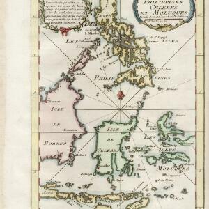
Carte des isles Philippines, Celebes et Moluques
c.1746-1770
Brunei, Malaysia, Philippines, Indonesia, East Timor
The note in French at the top left of this map states that although the map is accurate, the names of many small islands have been omitted to avoid confusion, and that more details will come later.

A new and accurate map of the East India Islands: laid down according to the latest discoveries, and agreeable to the most approved maps & charts
c.1744-1747
Brunei, Cambodia, East Timor, Indonesia, Laos, Malaysia, Myanmar, Philippines, Singapore, Southeast Asia, Thailand, Vietnam
This mid-18th century map of Southeast Asia includes written notes on goods produced and traded, geographical features, and wild animals found in each part of the region.

A map of Java, Borneo and the islands to the eastward of them as far as Nova Guinea
1744
Indonesia, East Timor
A simple mid-18th century map featuring Borneo, Java, Celebes (Sulawasi) and many other smaller islands as far as New Guinea to the east, and Timor to the south. The only details are the names of the islands and some larger settlements.
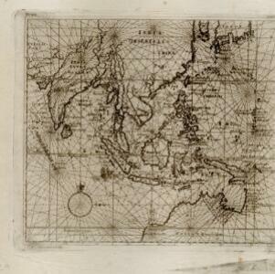
India orientalis
1744
Brunei, Cambodia, East Timor, Indonesia, Laos, Malaysia, Myanmar, Philippines, Singapore, Southeast Asia, Thailand, Vietnam
This map features a rhumbline network, a web of lines to help plot routes and aid navigation. Where the lines meet, there is a compass rose with an arrow pointing to north.

Particular-see-charte der Strass Sunda, nebst denen darinnen befindlichen insulen und sandbäncken
1744
Indonesia
A navigation map of part of the north coast of Java, featuring the ports of Batavia (Jakarta) and Bantam (Serang). Includes colourful paintings of a ‘menschen fressers [cannibal]’ island, Javanese people and palm trees (dates, banana, coconut).

A map of the dominions of Johore and of the island of Sumatra with the adjacent islands
1744
Indonesia, Malaysia, Singapore
A simple mid-18th century map featuring Sumatra and Johore (Peninsula Malaysia), and many small islands including Singapore. The only details are the names of the islands and some larger settlements.

Nuove carte delle Isole di Sunda come Borneo, Sumatra e Java Grande &c.
1740
Brunei, Cambodia, Indonesia, Malaysia, Singapore, Thailand
Based on a Dutch map of the Sunda Islands, with the text changed to Italian. Some Dutch remains e.g. a label on Borneo: ‘Beajous Afgoden dienars bewonende het middelste gedeelte vant Eilland [Beajous idolaters inhabit the middle part of the Island]’.


