Search

Search Results

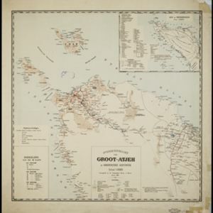
Overzichtskaart van Groot-Atjeh en aangrenzende kuststaten

event1898

location_onIndonesia

Map of Groot-Atjeh (Aceh, Sumatra), focusing on the area around the capital Kota Radja (Banda Aceh) and along the coasts. There is a list of telephone connections in the area, and an inset map of the region divided into administrative districts.

Atlas van Nederlandsch Oost-Indië

eventc.1897-1904

location_onIndonesia

Very detailed atlas of the entire Dutch East Indies, over 16 map sheets, with a cover and overview map. Includes topographic maps, inset maps of cities and islands, and maps featuring land and sea routes, languages, geology, colonial territory etc.

Ankerplaatsen en mondingen van rivieren op de Noord- en Oostkust van Sumatra: Blad I

event1896

location_onIndonesia

Eleven separate maps of bays and river mouths of Sumatra, including two bays on the island on Bras (Breueh Island), and the bay at Kota Radja (Banda Aceh). Bathymetry (sea depth), anchor points, reefs and shoals are marked, along with tide data.

Kaart van de residentie Oostkust van Sumatra

event1896

location_onIndonesia

Detailed topographical map of the east coast of Sumatra, spread over 36 sheets. The area’s farms are listed and shown on the map within yellow borders, with types of crop grown. There is a detailed plan of Medan, and five inset maps of other towns.

Sumatra: Residentie Benkoelen (Bengkoelen)

eventc.1894-1895

location_onIndonesia

Map of the residency of Benkoelen (Bengkulu, southwest coast of Sumatra), over 10 sheets, with an inset map of the city of Bengkoelen (Bengkulu). Types of crops—coconut, rice, alang-alang, nipah palm, coffee—are marked. Sheet number 8 is missing.

Kaart van de residentie Oostkust van Sumatra

event1889

location_onIndonesia

Detailed topographical map of the east coast of Sumatra, spread over 36 sheets plus a cover sheet of the whole area. Mountains and forests dominate, with villages, routes and administrative borders shown. With five inset maps of individual towns.

Schetskaart der afdeeling Westkust van Atjeh

event1888

location_onIndonesia

From a Dutch geographical society journal, this map of the west coast of Atjeh (Aceh), Sumatra, shows shoals, reefs, bathymetry (sea depth) and anchor points. On land, there are mountains (with heights), rivers, pepper plantations and rice fields.

Kaart van Atjeh en Onderhoorigheden

event1886

location_onIndonesia

This map of the Atjeh and its surrounding area (modern province of Aceh, Indonesia) is divided into administrative areas. There is an inset map of the capital city Kota Radja (Banda Aceh), and mountains (with their height) and rivers are marked.

Overzichtskaart van Groot-Atjeh

event1884

location_onIndonesia

Map of Groot-Atjeh (Aceh, Sumatra) divided into administrative districts. Mountains, forests, villages, railways, roads and rivers are marked. There are inset maps of Poeloe Bras (Breueh Island), and showing distances between larger settlements.

Topographische en geologische kaart van Zuid-Sumatra bevattende de residentien Bengkoelen, Palembang en Lampongsche Districten

event1880

location_onIndonesia

A topographical and geological map of southern Sumatra, over four sheets. Areas of igneous and sedimentary rock, coal, fossils, petroleum, active volcanoes and hot springs are marked, along with mountains, rivers and marshland, roads and settlements.

Algemeene kaart van Nederlandsch Oostindie

eventc.1839-1855

location_onEast Timor, Indonesia, Malaysia, Singapore

This map of the Dutch East Indies is spread over eight sheets, with a hand-drawn cover sheet showing the whole area. There are numerous inset maps of islands, bays, cities etc. Two of the inset maps have a replacement map pasted over them.

A new chart shewing the navigation through the Strait of Sunda to Batavia

event1815

location_onIndonesia

Navigation chart of the Sunda Strait, with sea depth, anchor points, shoals and other obstructions. Includes many bays, with four highlighted on inset maps. Partly based on writings of Captain Krusenstern whose 1806 route through the strait is shown.

close

  • Filter from 1815 to 1898

Current results range from 1815 to 1898