
Search Results
9 Results found


A map of the Malay Peninsula
1898
Malaysia, Singapore, Thailand
Map of the Malay Peninsula showcasing the Straits Settlements in pink, the Federated Malay States in red, and Siamese states in yellow. A table of common words in English, Malay and Siamese is included. Only four of six sheets are available.
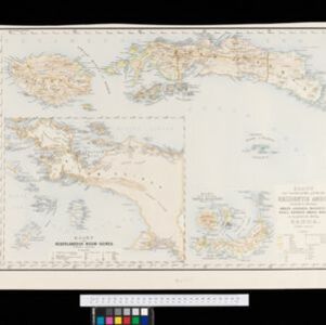
Kaart van 't noordwestelijke gedeelte der Residentie Ambon
1898
Indonesia
Map of the residency of Ambon in the Maluku Islands, divided by colour-coded administrative borders. There are inset maps the Banda Islands—including the nutmeg plantations and the town of Neira with its fort and hospital—and of Dutch New Guinea.

Atlas van Nederlandsch Oost-Indië
c.1897-1904
Indonesia
Very detailed atlas of the entire Dutch East Indies, over 16 map sheets, with a cover and overview map. Includes topographic maps, inset maps of cities and islands, and maps featuring land and sea routes, languages, geology, colonial territory etc.


Algemeene kaart van Nederlandsch Indië
1879
Cambodia, Indonesia, Papua New Guinea, East Timor, Southeast Asia, Thailand, Malaysia, Philippines, Laos, Vietnam, Singapore, Brunei, Myanmar
A late 19th century map of the Dutch East Indies on four sheets, detailing maritime routes around the region. There are also inset maps showing railways, rivers, roads, and telegraph systems, as well as individual islands and cities.

Map of the Malay Peninsula 1879
1879
Malaysia, Singapore, Thailand
Six-sheet map of the Malay Peninsula, featuring settlements, mountains and rivers. Labels note names of indigenous peoples, or describe terrain/resources. There is an inset map of Singapore town, and the Straits Settlements are highlighted in red.


Algemeene kaart van Nederlandsch Oostindie
c.1839-1855
East Timor, Indonesia, Malaysia, Singapore
This map of the Dutch East Indies is spread over eight sheets, with a hand-drawn cover sheet showing the whole area. There are numerous inset maps of islands, bays, cities etc. Two of the inset maps have a replacement map pasted over them.
- Filter from 1839 to 1898
- [remove]Inset Map9
- Legend9
- Coat of Arms3
- Illustration3
- Elevation2
- [remove]Contour Lines/Elevation9
- [remove]Longitude and Latitude9
- Scale9
- Compass Rose5
- Written Note/Details5


