
Search Results
93 Results found


Kaart van de Minahassa in de Residentie Manado
1853
Indonesia
Map of part of the Dutch colonial administrative region of Manado, on the Minahasa Peninsula, Celebes (Sulawesi). Includes an elevation view of the mountains. (From ‘Algemeene Atlas van Nederlandsche Indie [General Atlas of the Dutch East Indies]’.)
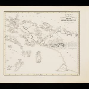
Kaart der Nederlandsche Bezittingen of het Eiland Nieuw-Guinea
1853
Indonesia
Map of Dutch colonial territory in New Guinea and nearby islands, featuring the 1850 route of the Dutch schooner Circe under Lieutenant Brutel de la Rivière. (From ‘Algemeene Atlas van Nederlandsche Indie [General Atlas of the Dutch East Indies]’.)

Kaart van het Eiland Nieuw-Guinea
1853
Indonesia, Papua New Guinea
Map featuring two maritime routes by Dutch explorers along the north coast of New Guinea: Jacob Le Maire and Willem Schouten (1616); and Abel Tasmanin (1648). (From ‘Algemeene Atlas van Nederlandsche Indie [General Atlas of the Dutch East Indies]’.)


Algemeene kaart van Nederlandsch Oostindie
c.1839-1855
East Timor, Indonesia, Malaysia, Singapore
This map of the Dutch East Indies is spread over eight sheets, with a hand-drawn cover sheet showing the whole area. There are numerous inset maps of islands, bays, cities etc. Two of the inset maps have a replacement map pasted over them.
- Filter from 1839 to 1899
- [remove]Dutch93
- [remove]Contour Lines/Elevation93
- [remove]Longitude and Latitude93
- Scale80
- Written Note/Details31
- Compass Rose25


