Search

Search Results

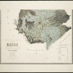
Topographische kaart der residentie Kadoe

event1870

location_onIndonesia

The residency of Kadoe (Kadu), Central Java, is shown divided into regencies and districts, with population figures for each district. Villages (kampongs) and towns, fields, mountains, rivers and roads are marked. There is an inset triangulation map.

Topographische kaart der residentie Japara

event1870

location_onIndonesia

Four-sheet topographic map of the residency of Japara (Jepara, Central Java), with an inset signal map of locations’ heights and distances. Administrative districts, crops—coffee, alang-alang, rice, sugarcane, coconut—and fishing ponds are shown.

Topographische kaart der residentie Djokjakarta

event1870

location_onIndonesia

The residency of Djokjakarta (Yogyakarta), southern Java, featuring crops (coffee, sugar, rice, alang-alang, tobacco, indigo plants, nipa palm, bamboo); warehouses, cemeteries, post offices; routes, administrative borders; mountains, rivers.

Topographische kaart der residentie Tagal

event1870

location_onIndonesia

The lower half of this two-sheet topographic map of the residency of Tagal (Tegal, Central Java) is dominated by mountains, with the upper half split between forests and rice paddies, and the larger settlements near the coast.

Kaart van de Minahassa in de residentie Manado

event1869

location_onIndonesia

On this map of the northern tip of the Minahasa Peninsula, the roads have been added in pencil after the map was printed. Similarly, the elevation (side view) of the peninsula’s mountains has the route of a journey added in pencil.

Topographische kaart der residentie Soerakarta

event1867

location_onIndonesia

The residency of Soerakarta (Surakarta), Central Java, featuring crops (coffee, sugarcane, rice, sugar); warehouses (coffee, sugar, tobacco, indigo plant); factories (sugar, tobacco, indigo plant); routes (railway, postal, road).

Kaart van de residentie Kadoe

event1867

location_onIndonesia

The residency of Kadoe in Central Java is shown divided into two regencies (yellow border) and 12 districts (blue borders). At the left edge, there are drawings (called elevations) of the side views of the area’s mountains, marked with their heights.

Kaart van de Zuider- en Ooster Afdeeling van Borneo

eventc.1865

location_onIndonesia

Map of the South and East Department of Borneo, focusing on the rivers and settlements along the rivers. The names of local districts are also printed on the map.

Topographische kaart van de residentie Banjoemaas

event1861

location_onIndonesia

The residency of Banjoemaas (Banyumas), Central Java, featuring plantations (bamboo, teakwood, coconut, coffee, cinnamon) and rice; routes (road, postal), administrative borders; mountains, rivers, wetlands, forests.

Kaart van de Adsistent Residentie Benkoelen en van de Eilanden Bewesten Sumatra

event1860

location_onIndonesia

Map of part of the Dutch colonial administrative region (assistant residency) of Benkoelen (Bengkulu, Sumatra), with an inset map of the Mentawai Islands. (From ‘Algemeene Atlas van Nederlandsche Indie [General Atlas of the Dutch East Indies]’.)

Kaart van de Adsistent Residentie Benkoelen: Middendeel

event1860

location_onIndonesia

Map of part of the Dutch colonial administrative region (assistant residency) of Benkoelen (Bengkulu, Sumatra). Inset map of Nias Island and the Batu Islands. (From ‘Algemeene Atlas van Nederlandsche Indie [General Atlas of the Dutch East Indies]’.)

Kaart van de Adsistent Residentie Benkoelen: Noorderdeel

event1860

location_onIndonesia

Map of part of the Dutch colonial administrative region (assistant residency) of Benkoelen (Bengkulu, Sumatra). There is an inset map of the Banyak Islands. (From ‘Algemeene Atlas van Nederlandsche Indie [General Atlas of the Dutch East Indies]’.)

close