
Search Results


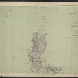
Carta general (en dos hojas) del Archipiélago Filipino
1900
Philippines
A Spanish military map of the northern Philippine island of Luzon, highlighting cable and telegraph lines, and aids to maritime navigation such as bathymetry (sea depth) and tide data. A conversion table for metres, fathoms and feet is also shown.


Map of the Kingdom of Siam and its dependencies
c.1900
Myanmar, Malaysia, Singapore, Thailand, Laos, Cambodia, Vietnam
The border of the Kingdom of Siam (Thailand) and its internal administrative districts are highlighted in yellow. Inset maps show the cities of Bangkok, Chiengmai (Chiang Mai) and Luang Pra Bang (Luang Prabang) in more detail.


[Various Indonesian islands]
c.1900
Malaysia, Brunei, Indonesia, Singapore
Seven locations in the Dutch East Indies on one sheet: the islands of Borneo, Sumatra, Celebes (Sulawesi), Ambon and Banda, the city of Padang and its region on the west coast of Sumatra, and the tip of the Minahasa Peninsula (northern Celebes).

A map of British North Borneo
1899
Malaysia, Brunei, Indonesia
The colonial territories of British North Borneo are shown in pink on this late 19th century map, with Brunei and Sarawak in green, and Dutch colonial territory in yellow. Sea routes around the British Empire are depicted on an inset map.


- Filter from 1775 to 1900
- Indonesia386
- Malaysia153
- Myanmar143
- Singapore121
- Thailand120
- Brunei102
- Vietnam98
- Philippines96
- Laos92
- East Timor91
- Cambodia90
- Southeast Asia67
- more Simple Location »
- Port48
- Railway Station23
- Pier10
- River410
- Road215
- Path143
- Postal Route82
- Railway/Tramway82
- Telegraph/Telephone35
- Canal23
- Bridge18
- [remove]Contour Lines/Elevation480
- [remove]Longitude and Latitude480
- Scale395
- Written Note/Details122
- Compass Rose63
- Rhumbline Network5


