Search

Search Results

[Pad van Tangsé naar Kroeng Sabé]

event1895

location_onIndonesia

Map of a path from Tangsé (Tangse) at the top right, southwest to Kroeng Sabi (Krueng Sabee) on the west coast of Aceh, Sumatra. The route crosses mountains and then follows a river to the coast.

Schetskaart der voormalige Ooster-buitenlinie

event1895

location_onIndonesia

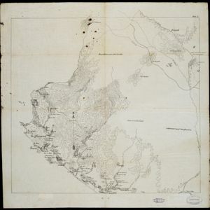
Produced during the Aceh War, the ‘Ooster-buitenlinie [Eastern outer line]’ of this map’s title probably refers to Dutch troop positions—marked with flag symbols—along the red road on the left. The road is east of the city of Kota Radja (Banda Aceh).

Residentie Soerabaja

event1895

location_onIndonesia

There are 64 sheets of this very large-scale (1:20,000) topographic map of the regency of Soerabaja (East Java). Cities and villages, roads, railways and rivers, crops and many more features are all shown in great detail. First sheet is an overview.

Topographische kaart der residentie Soerabaja

event1895

location_onIndonesia

The residency of Soerabaja, East Java, featuring crops (coffee, coconut, sugarcane, rice, alang-alang, bamboo) and fishing ponds. Three inset maps: a triangulation map; a map of distances between settlements by types of transport; Bawean Island.

Topographische kaart der residentie Tegal

event1895

location_onIndonesia

The lower half of this two-sheet topographic map of the residency of Tegal, Central Java is dominated by mountains, with the upper half split between forests and rice paddies, and the larger settlements near the coast.

Java

event1894

location_onIndonesia

This detailed late 19th century map shows Java divided into regencies, and features mountains, land and sea routes, and an inset map of the port city of Batavia (Jakarta). It was designed to be folded within book covers so it could be easily carried.

Koninginne baai met Emma haven

event1894

location_onIndonesia

Map of Koninginne Baai (Bayur Bay, west coast of Sumatra) used to navigate Emma Haven (now Port of Teluk Bayur). It features bathymetry (sea depth), reefs and shoals, as well as lighthouses, buoys and two elevations (side views) of coastal mountains.

Residentie Preanger Regentschappen

event1894

location_onIndonesia

Large-scale topographic map of the residency of Preanger (West Java) spread over multiple sheets plus a cover sheet of the whole area. It is divided into regencies, departments and districts. Only nine sheets and the cover sheet are available.

Topographische kaart van de residentie Preanger regentschappen

event1894

location_onIndonesia

The residency of Preanger (Parahyangan), West Java, with plantations (coconut, coffee, tea, cinchona (‘kina’), betel, teakwood, bamboo) and crops (rice, sugarcane, alang-alang). Two inset maps: a triangulation map, and a map of land route distances.

Topographische Kaart der residentie Cheribon

event1894

location_onIndonesia

Six-sheet topographic map of the residency of Cheribon (Cirebon, West Java), with an inset of a geodesic triangle grid. Administrative districts, crops—rice, alang-alang, sugarcane, sugar, coffee, tea—and indigo plant mills are shown.

A map of British North Borneo

event1894

location_onMalaysia, Brunei, Indonesia

The colonial territories of British North Borneo are shown in pink on this late 19th century map, with Brunei and Sarawak in green, and Dutch colonial territory in yellow. Sea routes around the British Empire are depicted on an inset map.

City of Mandalay and environs

event1894

location_onMyanmar

Map of the Burmese city of Mandalay on the Irrawaddy River. The city has a grid of roads and buildings, dominated by Fort Dufferin (formerly Mandalay Palace). The surrounding country has villages, crops, agricultural ponds and irrigation channels.

close